

- Forecast
- Maps
- Live
- Weather State
- Spot Information

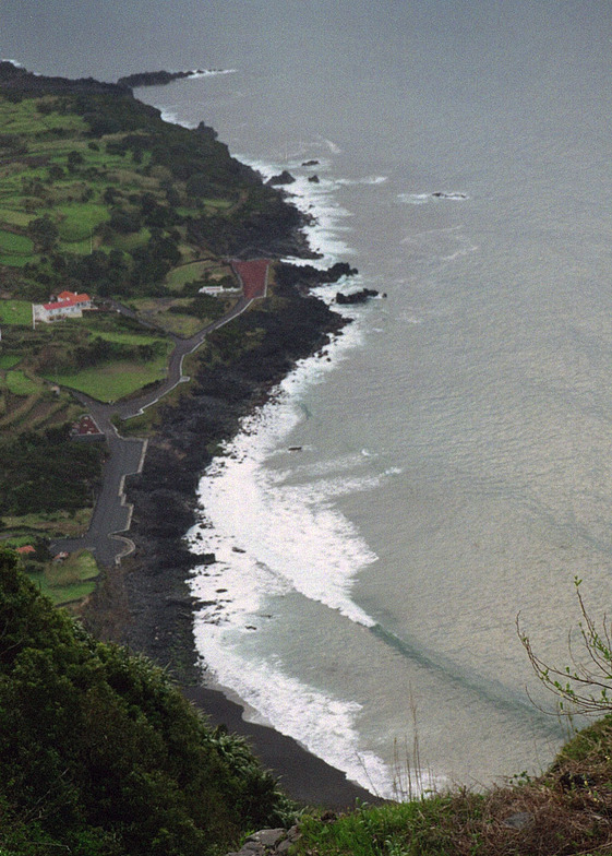
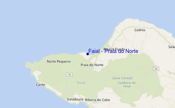
Faial - Praia do Norte surf Forecast / Azores / Portugal
- Map Icons:
 Break
Break Live Wave Height (m)
 Live Wind Speed (km/h)
 Surf Rating (10 Max)
 Ocean Swells (m)
- Wind Speed (km/h)
How big are the waves at Faial - Praia do Norte today?
The current surf forecast for Faial - Praia do Norte at 9AM is: 1.1m 12s primary swell from a Northwest direction and 1.4m 9s secondary swell from a West direction (forecast issued at 05:00am May 12). An open ocean swell of 0.2m 12s is not directed at the surf break. The wind direction is predicted to be cross-offshore and the swell rating is 3.
| Time (+00) & Date | Wave Height | Wave Period |
|---|---|---|
| Morning (12 May) | 3.5ft (1.1m) | 12s |
| Afternoon (12 May) | 5ft (1.6m) | 10s |
| Evening (12 May) | 6ft (1.8m) | 10s |
Table - waves today at Faial - Praia do Norte. (Swell directed towards the surf break)
Sunday 12 | Monday 13 | Tuesday 14 | Wednesday 15 | Thursday 16 | Friday 17 | Saturday 18 | Sunday 19 | |||||||||||||||||||||||||||||||||||||||||||||||||||||
| 3 AM | 6 AM | 9 AM | 12 PM | 3 PM | 6 PM | 9 PM | 0 AM | 3 AM | 6 AM | 9 AM | 12 PM | 3 PM | 6 PM | 9 PM | 0 AM | 3 AM | 6 AM | 9 AM | 12 PM | 3 PM | 6 PM | 9 PM | 0 AM | 3 AM | 6 AM | 9 AM | 12 PM | 3 PM | 6 PM | 9 PM | 0 AM | 3 AM | 6 AM | 9 AM | 12 PM | 3 PM | 6 PM | 9 PM | 0 AM | 3 AM | 6 AM | 9 AM | 12 PM | 3 PM | 6 PM | 9 PM | 0 AM | 3 AM | 6 AM | 9 AM | 12 PM | 3 PM | 6 PM | 9 PM | 0 AM | 3 AM | 6 AM | 9 AM | 12 PM | |
Rating (10 max) | ||||||||||||||||||||||||||||||||||||||||||||||||||||||||||||
Swell Height Map |    |  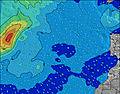 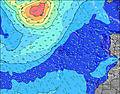 |  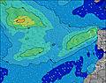 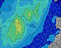 | 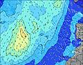 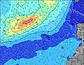  | 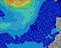 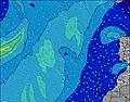 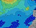 | 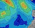 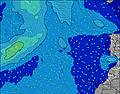 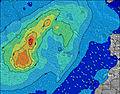 | 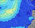 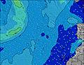 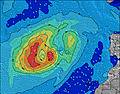 | 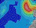 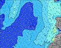 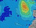 | ||||||||||||||||||||||||||||||||||||||||||||||||||||
| Wave Height (m) & direction (?) | ||||||||||||||||||||||||||||||||||||||||||||||||||||||||||||
| Period(s) (?) | 12 | 11 | 12 | 9 | 10 | 10 | 10 | 11 | 11 | 11 | 11 | 10 | 10 | 10 | 11 | 10 | 10 | 10 | 10 | 10 | 10 | 10 | 10 | 10 | 9 | 9 | 9 | 11 | 11 | 11 | 11 | 10 | 10 | 11 | 11 | 10 | 10 | 10 | 10 | 10 | 10 | 10 | 10 | 10 | 10 | 10 | 9 | 9 | 9 | 9 | 8 | 8 | 8 | 9 | 9 | 9 | 9 | 8 | 8 | 8 |
Wave (?)Graph | ||||||||||||||||||||||||||||||||||||||||||||||||||||||||||||
| Energy (?) | 361 | 363 | 343 | 409 | 435 | 517 | 731 | 787 | 787 | 668 | 531 | 432 | 410 | 349 | 284 | 338 | 318 | 362 | 415 | 415 | 472 | 474 | 464 | 408 | 375 | 320 | 270 | 196 | 200 | 196 | 200 | 192 | 185 | 196 | 196 | 185 | 212 | 178 | 178 | 178 | 175 | 151 | 148 | 175 | 132 | 145 | 130 | 124 | 82 | 96 | 90 | 82 | 41 | 73 | 61 | 50 | 37 | 35 | 35 | 54 |
Wind (km/h) | ||||||||||||||||||||||||||||||||||||||||||||||||||||||||||||
| Wind State (?) onshore cross-onshore cross-shore cross-offshore offshore glassy | cross- off | cross- off | cross- off | cross | cross | cross | cross- on | cross- on | cross- on | on | on | on | cross- on | cross- on | cross- on | cross- on | cross- on | cross- on | cross- on | cross- on | cross- on | cross- on | cross- on | cross- on | cross | cross- on | cross- on | cross- on | cross- on | cross- on | cross- on | cross- on | cross- on | cross- on | cross- on | cross- on | cross- on | cross- on | cross- on | cross- on | cross- on | cross- on | cross- on | cross- on | cross- on | cross- on | cross- on | cross- on | cross- on | cross- on | cross- on | cross- on | cross- on | cross- on | cross- on | cross- on | cross- on | glass | glass | glass |
High Tide / height (m) | 4:50AM 1.03 | 5:18PM 1.11 | 5:41AM 0.93 | 6:15PM 1.03 | 6:44AM 0.85 | 7:23PM 0.97 | 8:01AM 0.82 | 8:38PM 0.96 | 9:20AM 0.83 | 9:44PM 0.97 | 10:23AM 0.87 | 10:37PM 1.01 | 11:11AM 0.94 | 11:20PM 1.05 | 11:51AM 1.00 | |||||||||||||||||||||||||||||||||||||||||||||
Low Tide / height (m) | 10:52AM 0.26 | 11:40PM 0.33 | 11:42AM 0.34 | 12:45AM 0.40 | 12:44PM 0.41 | 2:02AM 0.43 | 1:59PM 0.44 | 3:18AM 0.42 | 3:14PM 0.44 | 4:17AM 0.38 | 4:16PM 0.41 | 5:02AM 0.33 | 5:05PM 0.36 | 5:39AM 0.27 | ||||||||||||||||||||||||||||||||||||||||||||||
Sunday 12 | Monday 13 | Tuesday 14 | Wednesday 15 | Thursday 16 | Friday 17 | Saturday 18 | Sunday 19 | |||||||||||||||||||||||||||||||||||||||||||||||||||||
| Sunrise | - | - | 6:45 | - | - | - | - | - | - | - | 6:43 | - | - | - | - | - | - | - | 6:43 | - | - | - | - | - | - | - | 6:41 | - | - | - | - | - | - | - | 6:41 | - | - | - | - | - | - | - | 6:41 | - | - | - | - | - | - | - | 6:39 | - | - | - | - | - | - | - | 6:39 | - |
| Sunset | - | - | - | - | - | 8:57 | - | - | - | - | - | - | - | 8:58 | - | - | - | - | - | - | - | 8:59 | - | - | - | - | - | - | - | - | 9:00 | - | - | - | - | - | - | - | 9:00 | - | - | - | - | - | - | - | 9:01 | - | - | - | - | - | - | - | 9:02 | - | - | - | - | - |
Rain (mm) | - | - | - | - | - | - | - | - | - | - | - | - | - | - | - | - | - | - | - | - | - | - | - | - | - | - | - | - | - | - | - | - | - | - | - | - | - | - | - | - | - | - | - | - | - | - | - | - | - | - | - | - | - | - | - | - | - | - | - | - |
| Temp. °C | 17 | 16 | 16 | 17 | 17 | 17 | 17 | 17 | 17 | 17 | 17 | 17 | 16 | 15 | 14 | 14 | 14 | 14 | 14 | 14 | 14 | 15 | 15 | 15 | 15 | 15 | 14 | 15 | 15 | 16 | 15 | 15 | 16 | 16 | 16 | 16 | 16 | 16 | 17 | 17 | 17 | 16 | 16 | 16 | 17 | 17 | 16 | 16 | 16 | 16 | 15 | 15 | 16 | 16 | 16 | 16 | 15 | 16 | 16 | 16 |
| Feels °C (?) | 16 | 15 | 15 | 16 | 16 | 16 | 16 | 17 | 17 | 16 | 16 | 16 | 13 | 11 | 9 | 9 | 9 | 9 | 9 | 9 | 8 | 10 | 10 | 11 | 11 | 11 | 10 | 12 | 12 | 13 | 12 | 12 | 14 | 14 | 14 | 14 | 13 | 13 | 14 | 15 | 15 | 14 | 13 | 14 | 16 | 15 | 13 | 14 | 14 | 13 | 12 | 13 | 14 | 15 | 15 | 15 | 14 | 16 | 17 | 16 |
FREE! Surf-Forecast.com widget for your website
The surf report / weather widget below is available to embed on third party websites free of charge and provides a summary of our Faial - Praia do Norte surf forecast. Simply grab the html code snippet that we provide and paste it into your own site. You can choose your preferred language and metric/imperial units for the surf forecast feed to suit users of your site. Click here to get the code.


 Nearest