

- Forecast
- Maps
- Live
- Weather State
- Spot Information
Bocabarranco Surf Forecast
/ Gran Canaria (26 surf breaks) /
Bocabarranco surfForecast / Gran Canaria / Spain
How big are the waves at Bocabarranco today?
The current surf forecast for Bocabarranco at 12PM is: 1.6m 5s primary swell from a North direction (forecast issued at 06:00am April 29). An open ocean swell of 0.1m 15s is not directed at the surf break, a second open ocean swell of 0.1m 11s is not directed at the surf break. The wind direction is predicted to be onshore.
| Time (WEST) & Date | Wave Height | Wave Period |
|---|---|---|
| Morning (29 Apr) | 4.5ft (1.4m) | 5s |
| Afternoon (29 Apr) | 5ft (1.6m) | 6s |
| Evening (29 Apr) | 6.5ft (2.0m) | 7s |
Table - waves today at Bocabarranco. (Swell directed towards the surf break)
Tuesday 29 | Wednesday 30 | Thursday 01 | Friday 02 | Saturday 03 | Sunday 04 | Monday 05 | Tuesday 06 | |||||||||||||||||||||||||||||||||||||||||||||||||||||
| 4 AM | 7 AM | 10 AM | 1 PM | 4 PM | 7 PM | 10 PM | 1 AM | 4 AM | 7 AM | 10 AM | 1 PM | 4 PM | 7 PM | 10 PM | 1 AM | 4 AM | 7 AM | 10 AM | 1 PM | 4 PM | 7 PM | 10 PM | 1 AM | 4 AM | 7 AM | 10 AM | 1 PM | 4 PM | 7 PM | 10 PM | 1 AM | 4 AM | 7 AM | 10 AM | 1 PM | 4 PM | 7 PM | 10 PM | 1 AM | 4 AM | 7 AM | 10 AM | 1 PM | 4 PM | 7 PM | 10 PM | 1 AM | 4 AM | 7 AM | 10 AM | 1 PM | 4 PM | 7 PM | 10 PM | 1 AM | 4 AM | 7 AM | 10 AM | 1 PM | |
Rating (10 max) | ||||||||||||||||||||||||||||||||||||||||||||||||||||||||||||
Swell Height Map |    |  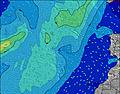 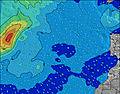 |  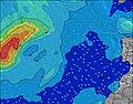 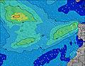 | 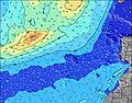 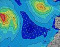 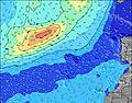 | 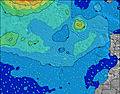 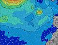 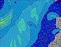 | 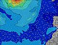 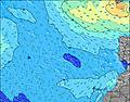 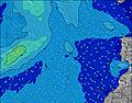 | 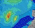 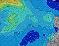 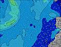 | 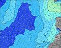 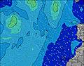 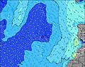 | ||||||||||||||||||||||||||||||||||||||||||||||||||||
| Wave Height (m) & direction (?) | ||||||||||||||||||||||||||||||||||||||||||||||||||||||||||||
| Period(s) (?) | 7 | 12 | 5 | 6 | 6 | 6 | 7 | 10 | 10 | 11 | 11 | 12 | 11 | 11 | 11 | 11 | 12 | 12 | 13 | 13 | 13 | 13 | 13 | 12 | 12 | 12 | 11 | 11 | 11 | 10 | 10 | 10 | 9 | 9 | 9 | 14 | 14 | 13 | 13 | 13 | 12 | 12 | 12 | 12 | 11 | 11 | 11 | 11 | 11 | 11 | 9 | 9 | 9 | 9 | 8 | 8 | 9 | 9 | 8 | 5 |
Wave (?)Graph | ||||||||||||||||||||||||||||||||||||||||||||||||||||||||||||
| Energy (?) | 181 | 94 | 112 | 163 | 187 | 272 | 395 | 772 | 884 | 1030 | 1032 | 1050 | 971 | 868 | 868 | 884 | 1006 | 1281 | 1703 | 2121 | 2548 | 2934 | 3065 | 2433 | 2440 | 1534 | 1087 | 807 | 672 | 522 | 437 | 351 | 293 | 266 | 218 | 186 | 170 | 156 | 195 | 147 | 131 | 125 | 125 | 123 | 113 | 135 | 133 | 130 | 121 | 91 | 90 | 86 | 79 | 78 | 140 | 177 | 186 | 186 | 147 | 50 |
Wind (km/h) | ||||||||||||||||||||||||||||||||||||||||||||||||||||||||||||
| Wind State (?) onshore cross-onshore cross-shore cross-offshore offshore glassy | on | on | on | on | on | on | on | on | on | on | cross- on | on | cross- on | cross- on | cross | cross- off | cross- off | cross- off | cross- off | cross- off | cross- on | on | cross- on | cross- on | cross- on | cross- on | on | on | cross- on | cross- on | on | on | on | on | cross- on | cross- on | on | on | on | cross- on | cross- on | cross- on | cross- on | cross- on | cross- on | cross- on | cross- on | cross- on | cross- on | cross- on | cross- on | cross- on | cross- on | cross- on | cross- on | cross- on | on | cross- on | on | cross- on |
High Tide / height (m) | 2:56AM 2.26 | 3:17PM 2.25 | 3:43AM 2.12 | 4:01PM 2.15 | 4:32AM 1.93 | 4:49PM 2.01 | 5:26AM 1.73 | 5:45PM 1.86 | 6:31AM 1.55 | 6:53PM 1.72 | 7:52AM 1.44 | 8:15PM 1.64 | 9:20AM 1.43 | 9:36PM 1.65 | 10:31AM 1.50 | |||||||||||||||||||||||||||||||||||||||||||||
Low Tide / height (m) | 9:02AM -0.02 | 9:27PM -0.03 | 9:44AM 0.12 | 10:15PM 0.09 | 10:29AM 0.29 | 11:09PM 0.25 | 11:19AM 0.48 | 12:12AM 0.42 | 12:20PM 0.64 | 1:32AM 0.56 | 1:42PM 0.75 | 3:04AM 0.60 | 3:14PM 0.76 | 4:18AM 0.56 | ||||||||||||||||||||||||||||||||||||||||||||||
Tuesday 29 | Wednesday 30 | Thursday 01 | Friday 02 | Saturday 03 | Sunday 04 | Monday 05 | Tuesday 06 | |||||||||||||||||||||||||||||||||||||||||||||||||||||
| Sunrise | - | - | 7:24 | - | - | - | - | - | - | - | 7:22 | - | - | - | - | - | - | - | 7:22 | - | - | - | - | - | - | - | 7:22 | - | - | - | - | - | - | - | 7:20 | - | - | - | - | - | - | - | 7:20 | - | - | - | - | - | - | - | 7:18 | - | - | - | - | - | - | - | 7:18 | - |
| Sunset | - | - | - | - | - | 8:35 | - | - | - | - | - | - | - | 8:36 | - | - | - | - | - | - | - | 8:36 | - | - | - | - | - | - | - | 8:37 | - | - | - | - | - | - | - | 8:37 | - | - | - | - | - | - | - | 8:37 | - | - | - | - | - | - | - | 8:38 | - | - | - | - | - | - |
Rain (mm) | - | - | - | - | - | - | - | - | - | - | - | - | - | - | - | - | - | - | - | - | - | - | - | - | - | - | - | - | - | - | - | - | - | - | - | - | - | - | - | - | - | - | - | - | - | - | - | - | - | - | - | - | - | - | - | - | - | - | - | - |
| Temp. °C | 17 | 17 | 18 | 18 | 18 | 18 | 17 | 17 | 17 | 17 | 17 | 18 | 18 | 18 | 18 | 18 | 17 | 17 | 18 | 19 | 20 | 19 | 19 | 18 | 18 | 18 | 18 | 19 | 19 | 19 | 19 | 18 | 18 | 17 | 18 | 19 | 19 | 19 | 18 | 18 | 18 | 17 | 18 | 19 | 19 | 19 | 18 | 18 | 18 | 17 | 18 | 19 | 19 | 19 | 18 | 18 | 17 | 17 | 18 | 19 |
| Feels °C (?) | 13 | 14 | 14 | 13 | 12 | 12 | 11 | 12 | 11 | 11 | 12 | 14 | 14 | 15 | 16 | 16 | 15 | 15 | 17 | 18 | 19 | 16 | 16 | 15 | 15 | 16 | 16 | 17 | 17 | 17 | 18 | 17 | 17 | 16 | 17 | 18 | 17 | 17 | 17 | 17 | 17 | 16 | 16 | 17 | 17 | 17 | 16 | 15 | 16 | 15 | 16 | 17 | 16 | 17 | 16 | 15 | 14 | 14 | 15 | 16 |
- Map Icons:
 Break
Break Live Wave Height (m)
 Live Wind Speed (km/h)
 Surf Rating (10 Max)
 Ocean Swells (m)
- Wind Speed (km/h)
FREE! Surf-Forecast.com widget for your website
The surf report / weather widget below is available to embed on third party websites free of charge and provides a summary of our Bocabarranco surf forecast. Simply grab the html code snippet that we provide and paste it into your own site. You can choose your preferred language and metric/imperial units for the surf forecast feed to suit users of your site. Click here to get the code.


 Nearest