

- Forecast
- Maps
- Live
- Weather State
- Spot Information

Bolina surfForecast / Lisboa / Portugal
How big are the waves at Bolina today?
The current surf forecast for Bolina at 1PM is: 0.9m 9s primary swell from a West-northwest direction and 1.2m 6s secondary swell from a South direction (forecast issued at 12:00pm April 29). An open ocean swell of 0.2m 10s is not directed at the surf break. The wind direction is predicted to be onshore.
| Time (WEST) & Date | Wave Height | Wave Period |
|---|---|---|
| Morning (29 Apr) | 3.5ft (1.0m) | 10s |
| Afternoon (29 Apr) | 3ft (0.9m) | 9s |
| Evening (29 Apr) | 4.5ft (1.4m) | 12s |
Table - waves today at Bolina. (Swell directed towards the surf break)
Tuesday 29 | Wednesday 30 | Thursday 01 | Friday 02 | Saturday 03 | Sunday 04 | Monday 05 | Tuesday 06 | |||||||||||||||||||||||||||||||||||||||||||||||||||||
| 10 AM | 1 PM | 4 PM | 7 PM | 10 PM | 1 AM | 4 AM | 7 AM | 10 AM | 1 PM | 4 PM | 7 PM | 10 PM | 1 AM | 4 AM | 7 AM | 10 AM | 1 PM | 4 PM | 7 PM | 10 PM | 1 AM | 4 AM | 7 AM | 10 AM | 1 PM | 4 PM | 7 PM | 10 PM | 1 AM | 4 AM | 7 AM | 10 AM | 1 PM | 4 PM | 7 PM | 10 PM | 1 AM | 4 AM | 7 AM | 10 AM | 1 PM | 4 PM | 7 PM | 10 PM | 1 AM | 4 AM | 7 AM | 10 AM | 1 PM | 4 PM | 7 PM | 10 PM | 1 AM | 4 AM | 7 AM | 10 AM | 1 PM | 4 PM | 7 PM | |
Rating (10 max) | ||||||||||||||||||||||||||||||||||||||||||||||||||||||||||||
Swell Height Map |    |  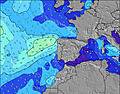 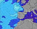 |  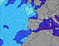 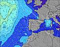 |  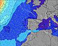 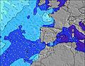 | 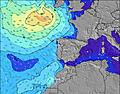 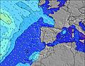 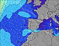 | 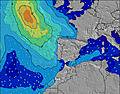 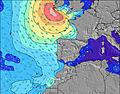 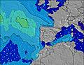 |    |    | ||||||||||||||||||||||||||||||||||||||||||||||||||||
| Wave Height (m) & direction (?) | ||||||||||||||||||||||||||||||||||||||||||||||||||||||||||||
| Period(s) (?) | 10 | 9 | 9 | 12 | 12 | 11 | 11 | 11 | 11 | 12 | 12 | 12 | 12 | 11 | 11 | 11 | 11 | 11 | 9 | 9 | 9 | 9 | 9 | 9 | 9 | 9 | 9 | 9 | 14 | 13 | 13 | 13 | 12 | 12 | 12 | 11 | 11 | 11 | 11 | 10 | 10 | 7 | 7 | 6 | 6 | 10 | 9 | 9 | 8 | 8 | 7 | 8 | 8 | 10 | 10 | 10 | 7 | 12 | 11 | 11 |
Wave (?)Graph | ||||||||||||||||||||||||||||||||||||||||||||||||||||||||||||
| Energy (?) | 179 | 149 | 116 | 322 | 648 | 705 | 757 | 680 | 650 | 805 | 859 | 980 | 923 | 1165 | 987 | 493 | 396 | 292 | 293 | 302 | 326 | 320 | 351 | 370 | 449 | 744 | 999 | 975 | 715 | 572 | 488 | 363 | 281 | 355 | 303 | 268 | 169 | 169 | 163 | 177 | 252 | 89 | 86 | 86 | 70 | 51 | 132 | 172 | 131 | 120 | 89 | 142 | 129 | 75 | 74 | 50 | 79 | 145 | 89 | 158 |
Wind (km/h) | ||||||||||||||||||||||||||||||||||||||||||||||||||||||||||||
| Wind State (?) onshore cross-onshore cross-shore cross-offshore offshore glassy | cross- on | on | on | on | on | on | on | on | on | cross- on | cross- on | cross- on | cross- on | cross- on | cross- on | cross | cross- on | cross- on | on | on | cross- on | cross- on | cross- on | cross- on | cross- on | on | on | on | on | on | on | on | on | on | on | on | on | on | cross- on | cross- on | cross | cross | cross | cross- off | cross- off | cross- off | cross- off | glass | glass | cross- off | cross- off | cross- off | cross- off | cross- off | cross- off | cross- off | cross- off | cross- off | cross- off | cross- off |
High Tide / height (m) | 4:34PM 3.65 | 5:00AM 3.48 | 5:19PM 3.54 | 5:50AM 3.26 | 6:08PM 3.36 | 6:44AM 3.01 | 7:04PM 3.16 | 7:49AM 2.79 | 8:10PM 2.98 | 9:06AM 2.64 | 9:28PM 2.87 | 10:30AM 2.62 | 10:48PM 2.86 | 11:42AM 2.70 | ||||||||||||||||||||||||||||||||||||||||||||||
Low Tide / height (m) | 10:17AM 0.59 | 10:43PM 0.58 | 11:01AM 0.76 | 11:32PM 0.73 | 11:46AM 0.98 | 12:24AM 0.94 | 12:38PM 1.23 | 1:27AM 1.16 | 1:40PM 1.45 | 2:46AM 1.33 | 3:03PM 1.59 | 4:15AM 1.38 | 4:34PM 1.60 | 5:30AM 1.34 | 5:45PM 1.50 | |||||||||||||||||||||||||||||||||||||||||||||
Tuesday 29 | Wednesday 30 | Thursday 01 | Friday 02 | Saturday 03 | Sunday 04 | Monday 05 | Tuesday 06 | |||||||||||||||||||||||||||||||||||||||||||||||||||||
| Sunrise | - | - | - | - | - | - | - | 6:41 | - | - | - | - | - | - | - | 6:39 | - | - | - | - | - | - | - | 6:39 | - | - | - | - | - | - | - | 6:37 | - | - | - | - | - | - | - | 6:37 | - | - | - | - | - | - | - | 6:35 | - | - | - | - | - | - | - | 6:35 | - | - | - | - |
| Sunset | - | - | - | 8:27 | - | - | - | - | - | - | - | 8:28 | - | - | - | - | - | - | - | 8:29 | - | - | - | - | - | - | - | 8:30 | - | - | - | - | - | - | - | 8:30 | - | - | - | - | - | - | - | 8:31 | - | - | - | - | - | - | - | 8:31 | - | - | - | - | - | - | - | 8:32 |
Rain (mm) | - | - | - | - | - | - | 1 | 2 | - | - | - | - | - | - | - | - | - | - | - | - | - | 1 | - | - | 2 | 1 | 1 | - | - | - | - | 1 | - | - | - | - | - | - | 1 | - | - | - | - | - | - | - | - | - | - | - | - | - | - | - | - | - | - | - | - | - |
| Temp. °C | 17 | 18 | 16 | 16 | 16 | 15 | 14 | 15 | 16 | 16 | 16 | 16 | 15 | 15 | 14 | 13 | 15 | 18 | 17 | 17 | 16 | 16 | 15 | 15 | 16 | 17 | 17 | 17 | 16 | 16 | 15 | 15 | 16 | 17 | 17 | 17 | 16 | 16 | 15 | 15 | 16 | 16 | 17 | 16 | 15 | 15 | 15 | 14 | 16 | 16 | 17 | 16 | 15 | 15 | 15 | 15 | 16 | 17 | 17 | 16 |
| Feels °C (?) | 12 | 14 | 12 | 13 | 13 | 11 | 11 | 12 | 12 | 12 | 13 | 14 | 13 | 13 | 11 | 10 | 11 | 14 | 14 | 16 | 15 | 13 | 12 | 10 | 9 | 10 | 10 | 12 | 13 | 13 | 12 | 13 | 12 | 13 | 14 | 15 | 14 | 14 | 14 | 14 | 15 | 14 | 15 | 14 | 14 | 14 | 15 | 14 | 16 | 14 | 15 | 14 | 13 | 13 | 13 | 13 | 14 | 14 | 14 | 13 |
- Map Icons:
 Break
Break Live Wave Height (m)
 Live Wind Speed (km/h)
 Surf Rating (10 Max)
 Ocean Swells (m)
- Wind Speed (km/h)
FREE! Surf-Forecast.com widget for your website
The surf report / weather widget below is available to embed on third party websites free of charge and provides a summary of our Bolina surf forecast. Simply grab the html code snippet that we provide and paste it into your own site. You can choose your preferred language and metric/imperial units for the surf forecast feed to suit users of your site. Click here to get the code.


 Nearest