

- Forecast
- Maps
- Live
- Weather State
- Spot Information

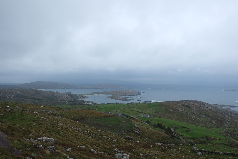
Derrynane surfForecast / Kerry / Ireland
How big are the waves at Derrynane today?
The current surf forecast for Derrynane at 2AM is: 0.9m 13s primary swell from a West-southwest direction (forecast issued at 12:00am April 19). An open ocean swell of 1.2m 11s is not directed at the surf break, a second open ocean swell of 0.5m 3s is not directed at the surf break. The wind direction is predicted to be cross-offshore.
| Time (IST) & Date | Wave Height | Wave Period |
|---|---|---|
| Morning (19 Apr) | 3.5ft (1.0m) | 12s |
| Afternoon (19 Apr) | 3.5ft (1.0m) | 12s |
| Evening (19 Apr) | 3.5ft (1.0m) | 12s |
Table - waves today at Derrynane. (Swell directed towards the surf break)
Saturday 19 | Sunday 20 | Monday 21 | Tuesday 22 | Wednesday 23 | Thursday 24 | Friday 25 | Saturday 26 | |||||||||||||||||||||||||||||||||||||||||||||||||||||
| 10 PM | 1 AM | 4 AM | 7 AM | 10 AM | 1 PM | 4 PM | 7 PM | 10 PM | 1 AM | 4 AM | 7 AM | 10 AM | 1 PM | 4 PM | 7 PM | 10 PM | 1 AM | 4 AM | 7 AM | 10 AM | 1 PM | 4 PM | 7 PM | 10 PM | 1 AM | 4 AM | 7 AM | 10 AM | 1 PM | 4 PM | 7 PM | 10 PM | 1 AM | 4 AM | 7 AM | 10 AM | 1 PM | 4 PM | 7 PM | 10 PM | 1 AM | 4 AM | 7 AM | 10 AM | 1 PM | 4 PM | 7 PM | 10 PM | 1 AM | 4 AM | 7 AM | 10 AM | 1 PM | 4 PM | 7 PM | 10 PM | 1 AM | 4 AM | 7 AM | |
Rating (10 max) | ||||||||||||||||||||||||||||||||||||||||||||||||||||||||||||
Swell Height Map |    |    |    |    |   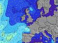 |    |   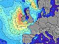 |  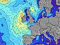 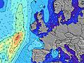 | 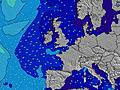 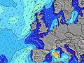 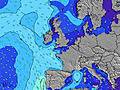 | |||||||||||||||||||||||||||||||||||||||||||||||||||
| Wave Height (m) & direction (?) | ||||||||||||||||||||||||||||||||||||||||||||||||||||||||||||
| Period(s) (?) | 14 | 13 | 13 | 12 | 12 | 12 | 12 | 12 | 12 | 12 | 11 | 11 | 11 | 11 | 11 | 11 | 10 | 10 | 10 | 10 | 11 | 11 | 11 | 11 | 11 | 11 | 11 | 10 | 6 | 9 | 10 | 10 | 10 | 6 | 9 | 9 | 10 | 11 | 11 | 11 | 11 | 11 | 11 | 11 | 12 | 11 | 11 | 12 | 14 | 13 | 13 | 13 | 13 | 12 | 12 | 12 | 13 | 13 | 12 | 12 |
Wave (?)Graph | ||||||||||||||||||||||||||||||||||||||||||||||||||||||||||||
| Energy (?) | 158 | 307 | 361 | 334 | 329 | 319 | 314 | 299 | 240 | 232 | 217 | 205 | 191 | 149 | 146 | 110 | 75 | 300 | 160 | 1397 | 2033 | 1968 | 1783 | 1492 | 1351 | 1116 | 1075 | 944 | 252 | 1469 | 1682 | 1368 | 0 | 30 | 497 | 449 | 479 | 584 | 595 | 661 | 517 | 457 | 469 | 495 | 532 | 522 | 454 | 602 | 1750 | 1619 | 1408 | 1230 | 1058 | 876 | 876 | 1025 | 1259 | 1230 | 1137 | 960 |
Wind (km/h) | ||||||||||||||||||||||||||||||||||||||||||||||||||||||||||||
| Wind State (?) onshore cross-onshore cross-shore cross-offshore offshore glassy | cross- off | cross- off | cross- off | cross- off | cross- off | cross- off | cross- off | cross- off | cross- off | cross- off | cross- off | cross- off | glass | on | on | cross- on | cross- on | cross | cross | cross | cross- on | cross- on | on | on | on | cross- on | cross- on | cross- on | cross- on | cross- on | cross- on | cross | cross- on | cross- on | cross- off | cross- off | cross- off | cross- off | cross- off | cross- off | cross- off | off | cross- off | cross- off | cross | cross | cross | cross | cross- off | cross- off | cross- off | cross- off | cross- off | cross | cross | glass | glass | glass | glass | cross- off |
High Tide / height (m) | 8:39PM 2.74 | 9:08AM 2.54 | 9:30PM 2.59 | 10:10AM 2.39 | 10:39PM 2.48 | 11:33AM 2.34 | 12:01AM 2.51 | 12:57PM 2.45 | 1:16AM 2.67 | 2:04PM 2.69 | 2:17AM 2.92 | 2:57PM 2.98 | 3:09AM 3.19 | 3:44PM 3.27 | 3:57AM 3.44 | |||||||||||||||||||||||||||||||||||||||||||||
Low Tide / height (m) | 2:41AM 0.95 | 2:56PM 1.10 | 3:36AM 1.11 | 3:57PM 1.25 | 4:58AM 1.17 | 5:29PM 1.29 | 6:33AM 1.06 | 7:01PM 1.16 | 7:44AM 0.80 | 8:06PM 0.91 | 8:37AM 0.49 | 8:57PM 0.62 | 9:23AM 0.19 | 9:43PM 0.34 | ||||||||||||||||||||||||||||||||||||||||||||||
Saturday 19 | Sunday 20 | Monday 21 | Tuesday 22 | Wednesday 23 | Thursday 24 | Friday 25 | Saturday 26 | |||||||||||||||||||||||||||||||||||||||||||||||||||||
| Sunrise | - | - | - | 6:37 | - | - | - | - | - | - | - | 6:35 | - | - | - | - | - | - | - | 6:31 | - | - | - | - | - | - | - | 6:30 | - | - | - | - | - | - | - | 6:28 | - | - | - | - | - | - | - | 6:26 | - | - | - | - | - | - | - | 6:24 | - | - | - | - | - | - | - | 6:22 |
| Sunset | - | - | - | - | - | - | - | 8:43 | - | - | - | - | - | - | - | 8:45 | - | - | - | - | - | - | - | 8:46 | - | - | - | - | - | - | - | 8:47 | - | - | - | - | - | - | - | 8:50 | - | - | - | - | - | - | - | 8:52 | - | - | - | - | - | - | - | 8:52 | - | - | - | - |
Rain (mm) | 1 | 1 | - | - | - | - | - | - | - | - | - | - | - | - | - | 1 | 2 | 1 | - | 1 | - | - | - | - | - | 1 | 1 | 1 | 1 | 6 | 3 | 1 | - | - | 2 | - | - | - | - | - | - | - | - | - | - | - | - | - | - | - | - | - | - | - | - | - | - | - | - | - |
| Temp. °C | 10 | 10 | 10 | 10 | 10 | 10 | 11 | 10 | 10 | 9 | 9 | 9 | 9 | 9 | 10 | 8 | 10 | 10 | 9 | 9 | 10 | 10 | 11 | 11 | 10 | 10 | 10 | 11 | 11 | 11 | 12 | 11 | 10 | 10 | 11 | 9 | 11 | 11 | 12 | 13 | 11 | 11 | 11 | 10 | 11 | 11 | 11 | 10 | 10 | 10 | 9 | 9 | 9 | 10 | 11 | 10 | 10 | 10 | 10 | 9 |
| Feels °C (?) | 5 | 6 | 6 | 6 | 5 | 5 | 6 | 5 | 6 | 4 | 5 | 7 | 7 | 6 | 5 | 4 | 8 | 5 | 4 | 3 | 4 | 6 | 7 | 7 | 6 | 6 | 5 | 5 | 5 | 3 | 8 | 8 | 5 | 4 | 7 | 4 | 6 | 6 | 8 | 9 | 8 | 9 | 9 | 7 | 7 | 5 | 5 | 4 | 6 | 6 | 5 | 6 | 6 | 7 | 8 | 8 | 9 | 9 | 8 | 7 |
- Map Icons:
 Break
Break Live Wave Height (m)
 Live Wind Speed (km/h)
 Surf Rating (10 Max)
 Ocean Swells (m)
- Wind Speed (km/h)
FREE! Surf-Forecast.com widget for your website
The surf report / weather widget below is available to embed on third party websites free of charge and provides a summary of our Derrynane surf forecast. Simply grab the html code snippet that we provide and paste it into your own site. You can choose your preferred language and metric/imperial units for the surf forecast feed to suit users of your site. Click here to get the code.


 Nearest