

- Forecast
- Maps
- Live
- Weather State
- Spot Information

Etang-Sale surfForecast / Réunion / Reunion
How big are the waves at Etang-Sale today?
The current surf forecast for Etang-Sale at 3PM is: 3.0m 16s primary swell from a South-southwest direction (forecast issued at 09:00am April 19). An open ocean swell of 1.1m 9s is not directed at the surf break, a second open ocean swell of 1.2m 9s is not directed at the surf break. The wind direction is predicted to be cross-onshore and the swell rating is 4.
| Time (+04) & Date | Wave Height | Wave Period |
|---|---|---|
| Morning (19 Apr) | 10ft (3.0m) | 16s |
| Afternoon (19 Apr) | 10ft (3.0m) | 16s |
| Evening (19 Apr) | 8ft (2.5m) | 16s |
Table - waves today at Etang-Sale. (Swell directed towards the surf break)
Saturday 19 | Sunday 20 | Monday 21 | Tuesday 22 | Wednesday 23 | Thursday 24 | Friday 25 | Saturday 26 | |||||||||||||||||||||||||||||||||||||||||||||||||||||
| 7 AM | 10 AM | 1 PM | 4 PM | 7 PM | 10 PM | 1 AM | 4 AM | 7 AM | 10 AM | 1 PM | 4 PM | 7 PM | 10 PM | 1 AM | 4 AM | 7 AM | 10 AM | 1 PM | 4 PM | 7 PM | 10 PM | 1 AM | 4 AM | 7 AM | 10 AM | 1 PM | 4 PM | 7 PM | 10 PM | 1 AM | 4 AM | 7 AM | 10 AM | 1 PM | 4 PM | 7 PM | 10 PM | 1 AM | 4 AM | 7 AM | 10 AM | 1 PM | 4 PM | 7 PM | 10 PM | 1 AM | 4 AM | 7 AM | 10 AM | 1 PM | 4 PM | 7 PM | 10 PM | 1 AM | 4 AM | 7 AM | 10 AM | 1 PM | 4 PM | |
Rating (10 max) | ||||||||||||||||||||||||||||||||||||||||||||||||||||||||||||
Swell Height Map | 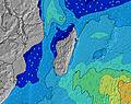 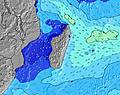 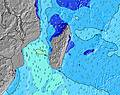 | 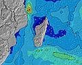 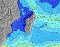 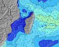 | 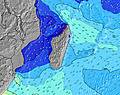 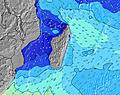 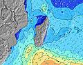 | 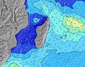 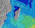 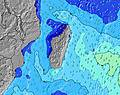 | 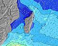 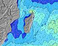 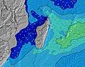 | 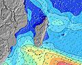 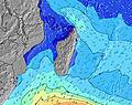 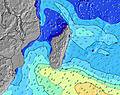 | 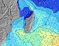 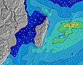 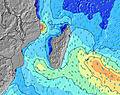 | 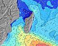 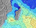 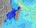 | ||||||||||||||||||||||||||||||||||||||||||||||||||||
| Wave Height (m) & direction (?) | ||||||||||||||||||||||||||||||||||||||||||||||||||||||||||||
| Period(s) (?) | 16 | 16 | 16 | 16 | 16 | 16 | 16 | 16 | 16 | 15 | 15 | 15 | 15 | 14 | 14 | 14 | 14 | 14 | 13 | 13 | 13 | 13 | 13 | 13 | 13 | 12 | 12 | 12 | 12 | 12 | 9 | 12 | 12 | 9 | 9 | 9 | 12 | 11 | 9 | 9 | 14 | 9 | 9 | 9 | 8 | 8 | 14 | 16 | 13 | 16 | 15 | 14 | 14 | 14 | 14 | 13 | 13 | 13 | 13 | 13 |
Wave (?)Graph | ||||||||||||||||||||||||||||||||||||||||||||||||||||||||||||
| Energy (?) | 3751 | 4036 | 4086 | 4277 | 3834 | 3693 | 3417 | 3074 | 2486 | 2329 | 1980 | 1953 | 1693 | 1600 | 1435 | 1187 | 1032 | 934 | 778 | 506 | 427 | 362 | 357 | 321 | 257 | 241 | 187 | 149 | 149 | 149 | 270 | 142 | 140 | 283 | 93 | 107 | 195 | 172 | 387 | 270 | 97 | 336 | 288 | 320 | 306 | 309 | 413 | 589 | 362 | 966 | 983 | 956 | 1061 | 1047 | 1003 | 905 | 878 | 769 | 757 | 623 |
Wind (km/h) | ||||||||||||||||||||||||||||||||||||||||||||||||||||||||||||
| Wind State (?) onshore cross-onshore cross-shore cross-offshore offshore glassy | glass | cross | cross- on | cross- on | glass | glass | glass | cross- on | on | glass | cross- off | cross | glass | glass | on | on | glass | cross- off | cross- off | off | off | off | cross- off | glass | off | off | off | off | off | off | off | off | cross- off | off | off | off | off | off | cross- off | glass | glass | cross | cross | off | off | off | off | glass | cross- off | glass | cross- off | off | off | off | off | glass | glass | glass | off | glass |
High Tide / height (m) | 3:56PM 0.33 | 3:19AM 0.43 | 5:03AM 0.39 | 9:53PM 0.39 | 8:12AM 0.40 | 10:11PM 0.46 | 9:32AM 0.46 | 10:38PM 0.53 | 10:24AM 0.52 | 11:08PM 0.58 | 11:10AM 0.57 | 11:39PM 0.62 | 11:53AM 0.59 | |||||||||||||||||||||||||||||||||||||||||||||||
Low Tide / height (m) | 9:36AM 0.17 | 8:28PM 0.27 | 11:06AM 0.21 | 2:08PM 0.20 | 3:03AM 0.32 | 3:19PM 0.16 | 3:56AM 0.26 | 4:04PM 0.11 | 4:35AM 0.19 | 4:43PM 0.07 | 5:13AM 0.13 | 5:21PM 0.05 | 5:50AM 0.07 | |||||||||||||||||||||||||||||||||||||||||||||||
Saturday 19 | Sunday 20 | Monday 21 | Tuesday 22 | Wednesday 23 | Thursday 24 | Friday 25 | Saturday 26 | |||||||||||||||||||||||||||||||||||||||||||||||||||||
| Sunrise | 6:31 | - | - | - | - | - | - | - | 6:31 | - | - | - | - | - | - | - | 6:31 | - | - | - | - | - | - | - | 6:31 | - | - | - | - | - | - | - | 6:31 | - | - | - | - | - | - | - | 6:33 | - | - | - | - | - | - | - | 6:33 | - | - | - | - | - | - | - | 6:33 | - | - | - |
| Sunset | - | - | - | 6:02 | - | - | - | - | - | - | - | 6:02 | - | - | - | - | - | - | - | 6:01 | - | - | - | - | - | - | - | 6:00 | - | - | - | - | - | - | - | 6:00 | - | - | - | - | - | - | - | 6:00 | - | - | - | - | - | - | - | 5:59 | - | - | - | - | - | - | - | 5:58 |
Rain (mm) | - | - | - | 1 | - | - | - | - | - | - | - | - | - | - | - | - | - | - | - | - | - | - | - | - | - | - | - | - | - | - | - | - | - | - | - | - | - | - | - | - | - | - | - | - | - | - | - | - | - | - | - | - | - | - | - | - | - | - | - | 1 |
| Temp. °C | 26 | 27 | 27 | 27 | 27 | 26 | 26 | 26 | 26 | 27 | 27 | 27 | 27 | 27 | 26 | 26 | 26 | 27 | 26 | 26 | 26 | 26 | 26 | 26 | 26 | 27 | 27 | 27 | 26 | 27 | 27 | 26 | 26 | 28 | 28 | 27 | 27 | 27 | 26 | 26 | 26 | 27 | 27 | 27 | 27 | 27 | 26 | 26 | 26 | 27 | 27 | 27 | 26 | 26 | 26 | 26 | 26 | 27 | 27 | 26 |
| Feels °C (?) | 30 | 30 | 31 | 30 | 32 | 30 | 31 | 29 | 29 | 31 | 30 | 30 | 32 | 32 | 29 | 29 | 30 | 30 | 29 | 29 | 29 | 29 | 29 | 29 | 29 | 28 | 29 | 28 | 27 | 28 | 30 | 29 | 28 | 30 | 30 | 28 | 28 | 30 | 28 | 30 | 30 | 30 | 30 | 30 | 31 | 30 | 28 | 29 | 29 | 30 | 30 | 30 | 27 | 26 | 28 | 29 | 29 | 30 | 30 | 30 |
- Map Icons:
 Break
Break Live Wave Height (m)
 Live Wind Speed (km/h)
 Surf Rating (10 Max)
 Ocean Swells (m)
- Wind Speed (km/h)
FREE! Surf-Forecast.com widget for your website
The surf report / weather widget below is available to embed on third party websites free of charge and provides a summary of our Etang-Sale surf forecast. Simply grab the html code snippet that we provide and paste it into your own site. You can choose your preferred language and metric/imperial units for the surf forecast feed to suit users of your site. Click here to get the code.


 Nearest