

- Forecast
- Maps
- Live
- Weather State
- Spot Information
4 Mile Surf Forecast
/ CAL – Santa Cruz (30 breaks) / California (404 breaks) /
4 Mile surfForecast / CAL – Santa Cruz / USA
How big are the waves at 4 Mile today?
The current surf forecast for 4 Mile at 11PM is: 3.0m 11s primary swell from a West-northwest direction and 0.4m 16s secondary swell from a South-southwest direction, 0.3m 13s secondary swell from a South-southwest direction (forecast issued at 04:00pm April 01). The wind direction is predicted to be cross-shore.
| Time (PDT) & Date | Wave Height | Wave Period |
|---|---|---|
| Morning (01 Apr) | - | - |
| Afternoon (01 Apr) | 11ft (3.5m) | 12s |
| Evening (01 Apr) | 10ft (3.0m) | 11s |
Table - waves today at 4 Mile. (Swell directed towards the surf break)
Tuesday 01 | Wednesday 02 | Thursday 03 | Friday 04 | Saturday 05 | Sunday 06 | Monday 07 | Tuesday 08 | |||||||||||||||||||||||||||||||||||||||||||||||||||||
| 2 PM | 5 PM | 8 PM | 11 PM | 2 AM | 5 AM | 8 AM | 11 AM | 2 PM | 5 PM | 8 PM | 11 PM | 2 AM | 5 AM | 8 AM | 11 AM | 2 PM | 5 PM | 8 PM | 11 PM | 2 AM | 5 AM | 8 AM | 11 AM | 2 PM | 5 PM | 8 PM | 11 PM | 2 AM | 5 AM | 8 AM | 11 AM | 2 PM | 5 PM | 8 PM | 11 PM | 2 AM | 5 AM | 8 AM | 11 AM | 2 PM | 5 PM | 8 PM | 11 PM | 2 AM | 5 AM | 8 AM | 11 AM | 2 PM | 5 PM | 8 PM | 11 PM | 2 AM | 5 AM | 8 AM | 11 AM | 2 PM | 5 PM | 8 PM | 11 PM | |
Rating (10 max) | ||||||||||||||||||||||||||||||||||||||||||||||||||||||||||||
Swell Height Map |  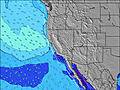  |    |    |  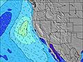 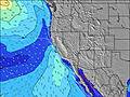 |  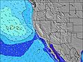 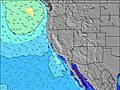 |  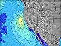 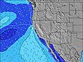 |  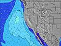 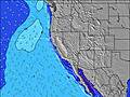 |  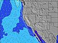 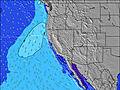 | ||||||||||||||||||||||||||||||||||||||||||||||||||||
| Wave Height (m) & direction (?) | ||||||||||||||||||||||||||||||||||||||||||||||||||||||||||||
| Period(s) (?) | 12 | 12 | 11 | 11 | 11 | 11 | 11 | 10 | 10 | 10 | 9 | 9 | 9 | 9 | 9 | 9 | 8 | 8 | 8 | 8 | 8 | 8 | 8 | 8 | 8 | 8 | 8 | 14 | 14 | 18 | 14 | 14 | 13 | 13 | 16 | 8 | 16 | 16 | 16 | 20 | 19 | 19 | 18 | 17 | 16 | 16 | 16 | 15 | 15 | 15 | 15 | 14 | 14 | 14 | 14 | 13 | 13 | 13 | 13 | 13 |
Wave (?)Graph | ||||||||||||||||||||||||||||||||||||||||||||||||||||||||||||
| Energy (?) | 3243 | 2201 | 2086 | 2187 | 2344 | 3109 | 2490 | 1140 | 1003 | 1055 | 833 | 690 | 1012 | 525 | 405 | 352 | 290 | 277 | 237 | 408 | 188 | 161 | 136 | 125 | 122 | 126 | 123 | 70 | 69 | 80 | 67 | 63 | 60 | 59 | 68 | 69 | 125 | 125 | 125 | 212 | 1229 | 2322 | 2702 | 3968 | 3786 | 3691 | 3388 | 3023 | 2877 | 2648 | 2361 | 2114 | 1886 | 1628 | 1482 | 1229 | 1230 | 1211 | 1103 | 909 |
Wind (km/h) | ||||||||||||||||||||||||||||||||||||||||||||||||||||||||||||
| Wind State (?) onshore cross-onshore cross-shore cross-offshore offshore glassy | cross- on | cross | cross | cross | cross | cross- off | cross- off | cross | cross | cross | cross | cross | cross- off | cross- off | cross- off | cross- on | cross- on | cross | cross- off | cross- off | glass | cross | off | on | cross | cross | cross- off | cross- off | glass | cross- off | glass | glass | cross | cross | cross- off | glass | glass | cross- off | glass | glass | cross- on | cross | cross | glass | glass | cross- off | cross- off | cross | cross | cross | cross- off | cross- off | cross- off | cross- off | cross- off | cross | cross | cross | cross- off | cross- off |
High Tide / height (m) | 2:24PM 1.62 | 1:21AM 2.25 | 3:47PM 1.53 | 2:13AM 2.15 | 5:21PM 1.52 | 3:18AM 2.03 | 6:47PM 1.56 | 4:36AM 1.93 | 7:46PM 1.63 | 5:58AM 1.87 | 8:27PM 1.70 | 7:10AM 1.85 | 9:00PM 1.77 | 8:09AM 1.83 | 9:26PM 1.83 | |||||||||||||||||||||||||||||||||||||||||||||
Low Tide / height (m) | 7:06PM 1.10 | 8:50AM 0.19 | 7:57PM 1.24 | 10:00AM 0.25 | 9:06PM 1.34 | 11:14AM 0.31 | 10:44PM 1.38 | 12:24PM 0.35 | 12:22AM 1.32 | 1:24PM 0.38 | 1:35AM 1.20 | 2:12PM 0.42 | 2:30AM 1.06 | 2:51PM 0.48 | ||||||||||||||||||||||||||||||||||||||||||||||
Tuesday 01 | Wednesday 02 | Thursday 03 | Friday 04 | Saturday 05 | Sunday 06 | Monday 07 | Tuesday 08 | |||||||||||||||||||||||||||||||||||||||||||||||||||||
| Sunrise | - | - | - | - | - | - | 6:52 | - | - | - | - | - | - | - | 6:52 | - | - | - | - | - | - | - | 6:50 | - | - | - | - | - | - | - | 6:48 | - | - | - | - | - | - | - | 6:47 | - | - | - | - | - | - | - | 6:46 | - | - | - | - | - | - | - | 6:43 | - | - | - | - | - |
| Sunset | - | 7:30 | - | - | - | - | - | - | - | 7:30 | - | - | - | - | - | - | - | 7:31 | - | - | - | - | - | - | - | 7:32 | - | - | - | - | - | - | - | 7:34 | - | - | - | - | - | - | - | 7:35 | - | - | - | - | - | - | - | 7:36 | - | - | - | - | - | - | - | 7:36 | - | - |
Rain (mm) | 1 | 1 | 1 | - | - | - | - | - | - | - | - | - | - | - | - | - | - | - | - | - | - | - | - | - | - | - | - | - | - | - | - | - | - | - | - | - | - | - | - | - | - | - | - | - | - | - | - | - | - | - | - | - | - | - | - | - | - | - | - | - |
| Temp. °C | 11 | 11 | 10 | 10 | 10 | 8 | 9 | 11 | 12 | 11 | 10 | 9 | 9 | 8 | 9 | 11 | 11 | 12 | 10 | 10 | 9 | 9 | 10 | 12 | 15 | 17 | 13 | 13 | 12 | 12 | 12 | 15 | 18 | 19 | 17 | 14 | 13 | 14 | 13 | 16 | 18 | 18 | 14 | 14 | 13 | 13 | 13 | 15 | 17 | 16 | 13 | 12 | 11 | 11 | 11 | 15 | 17 | 18 | 15 | 14 |
| Feels °C (?) | 5 | 4 | 3 | 2 | 2 | 4 | 5 | 4 | 4 | 3 | 3 | 3 | 4 | 4 | 6 | 9 | 7 | 7 | 5 | 7 | 7 | 6 | 8 | 10 | 10 | 12 | 8 | 10 | 10 | 10 | 10 | 13 | 15 | 15 | 13 | 12 | 11 | 12 | 11 | 14 | 14 | 12 | 9 | 14 | 13 | 12 | 11 | 11 | 11 | 10 | 9 | 9 | 8 | 8 | 9 | 12 | 12 | 13 | 12 | 11 |
- Map Icons:
 Break
Break Live Wave Height (m)
 Live Wind Speed (km/h)
 Surf Rating (10 Max)
 Ocean Swells (m)
- Wind Speed (km/h)
FREE! Surf-Forecast.com widget for your website
The surf report / weather widget below is available to embed on third party websites free of charge and provides a summary of our 4 Mile surf forecast. Simply grab the html code snippet that we provide and paste it into your own site. You can choose your preferred language and metric/imperial units for the surf forecast feed to suit users of your site. Click here to get the code.


 Nearest