

- Forecast
- Maps
- Live
- Weather State
- Spot Information

Furnas surfForecast / Ericeira / Portugal
How big are the waves at Furnas today?
The current surf forecast for Furnas at 1AM is: 1.1m 12s primary swell from a West-northwest direction and 0.8m 15s secondary swell from a West-northwest direction, 0.7m 5s secondary swell from a South direction (forecast issued at 06:00pm March 31). The wind direction is predicted to be cross-shore.
| Time (WEST) & Date | Wave Height | Wave Period |
|---|---|---|
| Morning (01 Apr) | 5ft (1.5m) | 13s |
| Afternoon (01 Apr) | 4.5ft (1.3m) | 12s |
| Evening (01 Apr) | 4.5ft (1.3m) | 11s |
Table - waves today at Furnas. (Swell directed towards the surf break)
Monday 31 | Tuesday 01 | Wednesday 02 | Thursday 03 | Friday 04 | Saturday 05 | Sunday 06 | Monday 07 | Tue 08 | ||||||||||||||||||||||||||||||||||||||||||||||||||||
| 4 PM | 7 PM | 10 PM | 1 AM | 4 AM | 7 AM | 10 AM | 1 PM | 4 PM | 7 PM | 10 PM | 1 AM | 4 AM | 7 AM | 10 AM | 1 PM | 4 PM | 7 PM | 10 PM | 1 AM | 4 AM | 7 AM | 10 AM | 1 PM | 4 PM | 7 PM | 10 PM | 1 AM | 4 AM | 7 AM | 10 AM | 1 PM | 4 PM | 7 PM | 10 PM | 1 AM | 4 AM | 7 AM | 10 AM | 1 PM | 4 PM | 7 PM | 10 PM | 1 AM | 4 AM | 7 AM | 10 AM | 1 PM | 4 PM | 7 PM | 10 PM | 1 AM | 4 AM | 7 AM | 10 AM | 1 PM | 4 PM | 7 PM | 10 PM | 1 AM | |
Rating (10 max) | ||||||||||||||||||||||||||||||||||||||||||||||||||||||||||||
Swell Height Map |   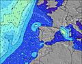 |  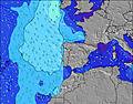 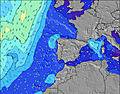 |  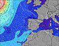 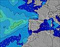 |  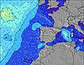 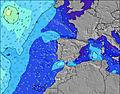 |  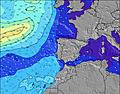 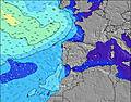 |  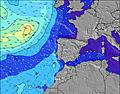 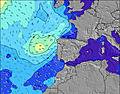 |  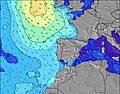 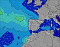 |  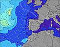 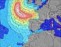 | 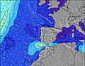   | |||||||||||||||||||||||||||||||||||||||||||||||||||
| Wave Height (m) & direction (?) | ||||||||||||||||||||||||||||||||||||||||||||||||||||||||||||
| Period(s) (?) | 12 | 11 | 11 | 12 | 14 | 13 | 13 | 12 | 12 | 12 | 11 | 11 | 11 | 11 | 12 | 12 | 12 | 11 | 11 | 15 | 14 | 13 | 13 | 12 | 11 | 11 | 11 | 10 | 10 | 11 | 11 | 10 | 10 | 10 | 10 | 9 | 9 | 9 | 8 | 8 | 8 | 8 | 8 | 8 | 8 | 8 | 7 | 13 | 13 | 12 | 12 | 12 | 11 | 13 | 13 | 13 | 12 | 12 | 12 | 11 |
Wave (?)Graph | ||||||||||||||||||||||||||||||||||||||||||||||||||||||||||||
| Energy (?) | 353 | 329 | 261 | 341 | 763 | 722 | 689 | 500 | 491 | 446 | 408 | 408 | 265 | 353 | 530 | 521 | 583 | 800 | 1389 | 4190 | 5511 | 4619 | 3498 | 918 | 769 | 686 | 564 | 249 | 3231 | 3962 | 3889 | 3087 | 2633 | 2156 | 1175 | 885 | 586 | 516 | 408 | 306 | 239 | 208 | 182 | 135 | 69 | 94 | 64 | 101 | 198 | 276 | 313 | 617 | 746 | 987 | 1192 | 728 | 547 | 298 | 237 | 170 |
Wind (km/h) | ||||||||||||||||||||||||||||||||||||||||||||||||||||||||||||
| Wind State (?) onshore cross-onshore cross-shore cross-offshore offshore glassy | cross | cross | cross | cross | cross- off | cross- off | cross- off | cross | cross | cross | cross- off | cross- off | cross- off | cross- off | cross | cross- on | cross- on | cross- on | cross | cross- off | cross- off | cross- off | cross- off | cross- off | cross- off | cross- off | cross- off | cross | cross | cross- off | cross | cross- on | cross- on | cross- on | cross- on | cross- on | cross | cross | cross | cross | cross | cross | cross- off | cross- off | cross- off | cross- off | cross- off | cross | cross | cross | cross- off | cross- off | cross- off | cross- off | cross- off | cross | cross | cross | cross- off | cross- off |
High Tide / height (m) | 4:53PM 3.12 | 5:14AM 3.10 | 5:35PM 2.99 | 6:01AM 2.85 | 6:21PM 2.80 | 6:53AM 2.54 | 7:15PM 2.56 | 7:57AM 2.23 | 8:23PM 2.33 | 9:22AM 2.02 | 9:54PM 2.21 | 11:01AM 1.99 | 11:26PM 2.25 | 12:19PM 2.10 | 12:33AM 2.39 | |||||||||||||||||||||||||||||||||||||||||||||
Low Tide / height (m) | 10:59PM -0.10 | 11:21AM 0.01 | 11:45PM 0.06 | 12:05PM 0.26 | 12:35AM 0.29 | 12:53PM 0.56 | 1:35AM 0.56 | 1:54PM 0.83 | 2:56AM 0.79 | 3:21PM 1.02 | 4:41AM 0.86 | 5:05PM 1.02 | 6:08AM 0.76 | 6:21PM 0.89 | ||||||||||||||||||||||||||||||||||||||||||||||
Monday 31 | Tuesday 01 | Wednesday 02 | Thursday 03 | Friday 04 | Saturday 05 | Sunday 06 | Monday 07 | Tue 08 | ||||||||||||||||||||||||||||||||||||||||||||||||||||
| Sunrise | - | - | - | - | - | - | 7:22 | - | - | - | - | - | - | - | 7:20 | - | - | - | - | - | - | - | 7:20 | - | - | - | - | - | - | - | 7:18 | - | - | - | - | - | - | - | 7:16 | - | - | - | - | - | - | - | 7:15 | - | - | - | - | - | - | - | 7:13 | - | - | - | - | - |
| Sunset | - | 7:59 | - | - | - | - | - | - | - | 8:00 | - | - | - | - | - | - | - | 8:00 | - | - | - | - | - | - | - | 8:01 | - | - | - | - | - | - | - | 8:02 | - | - | - | - | - | - | - | 8:04 | - | - | - | - | - | - | - | 8:05 | - | - | - | - | - | - | - | 8:06 | - | - |
Rain (mm) | - | - | - | - | - | - | - | - | - | - | - | - | - | - | 2 | 4 | 1 | - | - | - | 1 | 1 | 1 | - | - | 2 | 6 | 3 | 1 | 2 | 3 | 1 | - | - | - | - | - | - | - | - | - | - | - | - | 1 | 2 | - | - | - | - | - | - | - | - | - | - | - | - | - | - |
| Temp. °C | 19 | 17 | 16 | 15 | 14 | 15 | 16 | 17 | 17 | 17 | 15 | 15 | 15 | 14 | 13 | 13 | 14 | 14 | 13 | 13 | 13 | 13 | 14 | 16 | 17 | 14 | 14 | 14 | 14 | 14 | 15 | 15 | 15 | 15 | 15 | 14 | 15 | 15 | 15 | 16 | 17 | 16 | 15 | 15 | 15 | 14 | 15 | 17 | 18 | 17 | 16 | 15 | 15 | 15 | 16 | 19 | 20 | 19 | 18 | 18 |
| Feels °C (?) | 15 | 14 | 14 | 14 | 13 | 14 | 14 | 14 | 14 | 14 | 13 | 13 | 12 | 9 | 7 | 6 | 8 | 9 | 8 | 8 | 8 | 7 | 8 | 9 | 11 | 6 | 6 | 6 | 6 | 6 | 7 | 7 | 8 | 9 | 10 | 10 | 12 | 12 | 12 | 11 | 13 | 13 | 13 | 12 | 13 | 12 | 12 | 14 | 15 | 15 | 15 | 13 | 13 | 13 | 13 | 16 | 17 | 17 | 16 | 17 |
- Map Icons:
 Break
Break Live Wave Height (m)
 Live Wind Speed (km/h)
 Surf Rating (10 Max)
 Ocean Swells (m)
- Wind Speed (km/h)
FREE! Surf-Forecast.com widget for your website
The surf report / weather widget below is available to embed on third party websites free of charge and provides a summary of our Furnas surf forecast. Simply grab the html code snippet that we provide and paste it into your own site. You can choose your preferred language and metric/imperial units for the surf forecast feed to suit users of your site. Click here to get the code.


 Nearest