

- Forecast
- Maps
- Live
- Weather State
- Spot Information

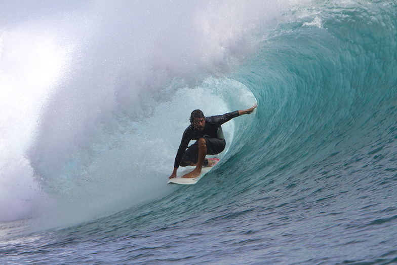
Grajagan Bay/G-Land surfForecast / Java – East / Indonesia
How big are the waves at Grajagan Bay/G-Land today?
The current surf forecast for Grajagan Bay/G-Land at 10AM is: 1.4m 13s primary swell from a South-southwest direction and 1.1m 11s secondary swell from a Southeast direction (forecast issued at 06:00am April 17). The wind direction is predicted to be cross-onshore and the swell rating is 2.
| Time (WIB) & Date | Wave Height | Wave Period |
|---|---|---|
| Morning (17 Apr) | 4.5ft (1.4m) | 14s |
| Afternoon (17 Apr) | 4ft (1.2m) | 13s |
| Evening (17 Apr) | 4ft (1.2m) | 13s |
Table - waves today at Grajagan Bay/G-Land. (Swell directed towards the surf break)
Thursday 17 | Friday 18 | Saturday 19 | Sunday 20 | Monday 21 | Tuesday 22 | Wednesday 23 | Thursday 24 | |||||||||||||||||||||||||||||||||||||||||||||||||||||
| 4 AM | 7 AM | 10 AM | 1 PM | 4 PM | 7 PM | 10 PM | 1 AM | 4 AM | 7 AM | 10 AM | 1 PM | 4 PM | 7 PM | 10 PM | 1 AM | 4 AM | 7 AM | 10 AM | 1 PM | 4 PM | 7 PM | 10 PM | 1 AM | 4 AM | 7 AM | 10 AM | 1 PM | 4 PM | 7 PM | 10 PM | 1 AM | 4 AM | 7 AM | 10 AM | 1 PM | 4 PM | 7 PM | 10 PM | 1 AM | 4 AM | 7 AM | 10 AM | 1 PM | 4 PM | 7 PM | 10 PM | 1 AM | 4 AM | 7 AM | 10 AM | 1 PM | 4 PM | 7 PM | 10 PM | 1 AM | 4 AM | 7 AM | 10 AM | 1 PM | |
Rating (10 max) | ||||||||||||||||||||||||||||||||||||||||||||||||||||||||||||
Swell Height Map |    |    |    |    |    |    |    |    | ||||||||||||||||||||||||||||||||||||||||||||||||||||
| Wave Height (m) & direction (?) | ||||||||||||||||||||||||||||||||||||||||||||||||||||||||||||
| Period(s) (?) | 14 | 14 | 13 | 13 | 13 | 13 | 13 | 16 | 15 | 15 | 15 | 17 | 16 | 16 | 16 | 15 | 15 | 15 | 15 | 15 | 15 | 15 | 14 | 14 | 14 | 14 | 14 | 14 | 14 | 14 | 14 | 14 | 13 | 13 | 13 | 13 | 13 | 13 | 12 | 12 | 12 | 12 | 16 | 20 | 20 | 19 | 19 | 18 | 18 | 18 | 17 | 17 | 17 | 16 | 16 | 16 | 16 | 16 | 16 | 16 |
Wave (?)Graph | ||||||||||||||||||||||||||||||||||||||||||||||||||||||||||||
| Energy (?) | 712 | 799 | 722 | 346 | 543 | 469 | 469 | 1016 | 1014 | 949 | 962 | 1175 | 1804 | 1393 | 1493 | 1418 | 1364 | 1393 | 1374 | 1374 | 1292 | 1145 | 1670 | 1114 | 982 | 969 | 1189 | 1280 | 1280 | 1189 | 1138 | 1106 | 1028 | 905 | 892 | 878 | 732 | 721 | 585 | 557 | 477 | 469 | 405 | 557 | 746 | 1077 | 1011 | 1839 | 1818 | 1952 | 2212 | 2323 | 2242 | 2162 | 1977 | 1928 | 1765 | 1765 | 1765 | 1591 |
Wind (km/h) | ||||||||||||||||||||||||||||||||||||||||||||||||||||||||||||
| Wind State (?) onshore cross-onshore cross-shore cross-offshore offshore glassy | glass | on | cross- on | cross- on | cross- on | on | on | on | on | on | on | cross- on | cross- on | cross- on | cross | cross | cross- on | glass | on | on | on | cross- on | cross- on | on | on | on | on | cross- on | cross- on | cross- on | glass | glass | glass | glass | glass | cross- off | cross- off | cross- off | off | glass | glass | glass | glass | cross- off | cross- off | cross- off | off | off | cross- off | cross- off | cross- off | cross- off | cross- off | cross- off | off | glass | glass | glass | glass | cross- off |
High Tide / height (m) | 10:50AM 2.51 | 11:27PM 1.93 | 11:15AM 2.41 | 11:55PM 1.78 | 11:41AM 2.29 | 12:28AM 1.62 | 12:10PM 2.14 | 1:15AM 1.48 | 12:49PM 1.97 | 3:03AM 1.39 | 2:05PM 1.78 | 5:51AM 1.53 | 4:47PM 1.73 | 6:38AM 1.79 | ||||||||||||||||||||||||||||||||||||||||||||||
Low Tide / height (m) | 4:40AM 0.57 | 5:24PM 0.23 | 5:01AM 0.66 | 5:54PM 0.36 | 5:23AM 0.78 | 6:28PM 0.52 | 5:45AM 0.93 | 7:12PM 0.69 | 6:11AM 1.09 | 8:22PM 0.85 | 7:07AM 1.28 | 10:18PM 0.90 | 10:42AM 1.33 | 11:52PM 0.83 | 12:29PM 1.06 | |||||||||||||||||||||||||||||||||||||||||||||
Thursday 17 | Friday 18 | Saturday 19 | Sunday 20 | Monday 21 | Tuesday 22 | Wednesday 23 | Thursday 24 | |||||||||||||||||||||||||||||||||||||||||||||||||||||
| Sunrise | - | 5:24 | - | - | - | - | - | - | - | 5:24 | - | - | - | - | - | - | - | 5:24 | - | - | - | - | - | - | - | 5:24 | - | - | - | - | - | - | - | 5:24 | - | - | - | - | - | - | - | 5:24 | - | - | - | - | - | - | - | 5:24 | - | - | - | - | - | - | - | 5:24 | - | - |
| Sunset | - | - | - | - | 5:19 | - | - | - | - | - | - | - | 5:17 | - | - | - | - | - | - | - | 5:17 | - | - | - | - | - | - | - | 5:16 | - | - | - | - | - | - | - | 5:16 | - | - | - | - | - | - | - | 5:16 | - | - | - | - | - | - | - | 5:15 | - | - | - | - | - | - | - |
Rain (mm) | 2 | - | - | - | 1 | 3 | 4 | 1 | 1 | - | 1 | 1 | 4 | 12 | 3 | 2 | - | - | - | 1 | 1 | 2 | - | - | - | - | 2 | 3 | 1 | 1 | 1 | - | - | - | - | - | - | - | - | - | - | - | - | - | - | 1 | 3 | 4 | 6 | 6 | 2 | 2 | - | 1 | 1 | 1 | 4 | 1 | - | 1 |
| Temp. °C | 26 | 27 | 28 | 29 | 28 | 27 | 27 | 26 | 26 | 27 | 28 | 29 | 28 | 26 | 25 | 24 | 25 | 25 | 28 | 29 | 28 | 27 | 26 | 26 | 26 | 27 | 27 | 28 | 28 | 27 | 27 | 26 | 26 | 26 | 28 | 29 | 28 | 27 | 27 | 26 | 26 | 27 | 28 | 29 | 28 | 27 | 26 | 26 | 26 | 27 | 29 | 28 | 28 | 27 | 27 | 26 | 26 | 26 | 28 | 28 |
| Feels °C (?) | 30 | 32 | 32 | 32 | 31 | 31 | 31 | 29 | 29 | 30 | 32 | 32 | 32 | 30 | 28 | 27 | 28 | 29 | 31 | 31 | 30 | 31 | 30 | 29 | 29 | 30 | 30 | 30 | 31 | 31 | 32 | 30 | 31 | 31 | 34 | 33 | 31 | 31 | 31 | 30 | 30 | 32 | 32 | 32 | 30 | 30 | 30 | 30 | 30 | 31 | 32 | 31 | 31 | 31 | 31 | 31 | 30 | 31 | 32 | 32 |
- Map Icons:
 Break
Break Live Wave Height (m)
 Live Wind Speed (km/h)
 Surf Rating (10 Max)
 Ocean Swells (m)
- Wind Speed (km/h)
FREE! Surf-Forecast.com widget for your website
The surf report / weather widget below is available to embed on third party websites free of charge and provides a summary of our Grajagan Bay/G-Land surf forecast. Simply grab the html code snippet that we provide and paste it into your own site. You can choose your preferred language and metric/imperial units for the surf forecast feed to suit users of your site. Click here to get the code.


 Nearest