

- Forecast
- Maps
- Live
- Weather State
- Spot Information
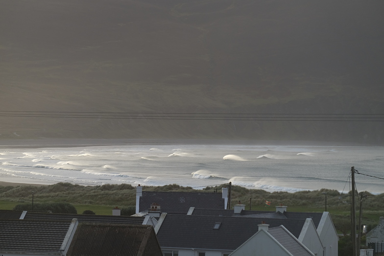
Keel Surf Forecast
/ Mayo and Achill Island (14 surf breaks) /
Surf Forecasts
Keel surfForecast / Mayo and Achill Island / Ireland
Forecast update in hr min s Forecast update imminent
Keel surf forecast is for near shore open water. Breaking waves will often be smaller at less exposed spots.
Today's Keel sea temperature is
10.6° C
(Which is slightly warmer than usual)How big are the waves at Keel today?
The current surf forecast for Keel at 8AM is: 1.0m 13s primary swell from a West direction and 0.3m 13s secondary swell from a West direction (forecast issued at 06:00am April 19). An open ocean swell of 2.5m 9s is not directed at the surf break. The wind direction is predicted to be cross-offshore.
| Time (IST) & Date | Wave Height | Wave Period |
|---|---|---|
| Morning (19 Apr) | 3.5ft (1.0m) | 13s |
| Afternoon (19 Apr) | 3.5ft (1.0m) | 12s |
| Evening (19 Apr) | 3.5ft (1.0m) | 12s |
Table - waves today at Keel. (Swell directed towards the surf break)
Updates in hr min s Forecast update imminent
Saturday 19 | Sunday 20 | Monday 21 | Tuesday 22 | Wednesday 23 | Thursday 24 | Friday 25 | Saturday 26 | |||||||||||||||||||||||||||||||||||||||||||||||||||||
| 4 AM | 7 AM | 10 AM | 1 PM | 4 PM | 7 PM | 10 PM | 1 AM | 4 AM | 7 AM | 10 AM | 1 PM | 4 PM | 7 PM | 10 PM | 1 AM | 4 AM | 7 AM | 10 AM | 1 PM | 4 PM | 7 PM | 10 PM | 1 AM | 4 AM | 7 AM | 10 AM | 1 PM | 4 PM | 7 PM | 10 PM | 1 AM | 4 AM | 7 AM | 10 AM | 1 PM | 4 PM | 7 PM | 10 PM | 1 AM | 4 AM | 7 AM | 10 AM | 1 PM | 4 PM | 7 PM | 10 PM | 1 AM | 4 AM | 7 AM | 10 AM | 1 PM | 4 PM | 7 PM | 10 PM | 1 AM | 4 AM | 7 AM | 10 AM | 1 PM | |
Rating (10 max) | ||||||||||||||||||||||||||||||||||||||||||||||||||||||||||||
Swell Height Map |    |    |    |    |   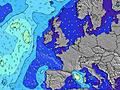 |  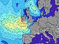 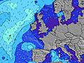 |  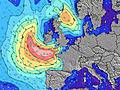 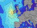 | 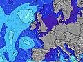 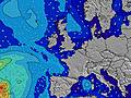 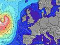 | ||||||||||||||||||||||||||||||||||||||||||||||||||||
| Wave Height (m) & direction (?) | ||||||||||||||||||||||||||||||||||||||||||||||||||||||||||||
| Period(s) (?) | 13 | 13 | 13 | 13 | 12 | 12 | 12 | 12 | 11 | 11 | 11 | 11 | 11 | 11 | 10 | 10 | 10 | 10 | 11 | 12 | 12 | 12 | 12 | 11 | 11 | 10 | 10 | 10 | 9 | 9 | 9 | 9 | 9 | 9 | 10 | 10 | 11 | 11 | 11 | 11 | 11 | 12 | 12 | 11 | 15 | 14 | 14 | 13 | 13 | 13 | 12 | 12 | 12 | 12 | 12 | 13 | 13 | 12 | 12 | 12 |
Wave (?)Graph | ||||||||||||||||||||||||||||||||||||||||||||||||||||||||||||
| Energy (?) | 290 | 339 | 329 | 324 | 309 | 299 | 285 | 224 | 209 | 198 | 151 | 149 | 112 | 110 | 74 | 51 | 73 | 610 | 1348 | 2501 | 2693 | 2679 | 2377 | 1732 | 1405 | 968 | 849 | 669 | 711 | 723 | 375 | 300 | 254 | 265 | 332 | 374 | 449 | 449 | 396 | 388 | 338 | 397 | 411 | 454 | 440 | 1335 | 1362 | 1264 | 1249 | 1295 | 1236 | 1197 | 1052 | 992 | 960 | 1207 | 1226 | 972 | 940 | 710 |
Wind (km/h) | ||||||||||||||||||||||||||||||||||||||||||||||||||||||||||||
| Wind State (?) onshore cross-onshore cross-shore cross-offshore offshore glassy | off | cross- off | cross- off | cross- off | cross- off | cross- off | cross- off | cross | cross | cross- on | cross- on | cross- on | cross- on | on | cross- on | cross- on | cross- on | cross- on | cross- on | on | on | on | cross- on | cross- on | cross- on | cross- on | cross- on | cross | cross- on | cross | cross- on | cross- off | cross- off | cross- off | cross- off | off | cross- off | cross- off | cross- off | cross- off | cross- off | cross- off | cross | cross | cross- on | cross | cross | cross | cross | cross | cross- on | cross- on | on | glass | cross- on | cross- on | cross | cross | cross | cross- on |
High Tide / height (m) | 10:01AM 2.66 | 10:20PM 2.84 | 11:04AM 2.48 | 11:29PM 2.72 | 12:34PM 2.42 | 12:55AM 2.73 | 2:05PM 2.57 | 2:13AM 2.90 | 3:13PM 2.86 | 3:15AM 3.16 | 4:04PM 3.21 | 4:07AM 3.45 | 4:49PM 3.55 | 4:54AM 3.72 | ||||||||||||||||||||||||||||||||||||||||||||||
Low Tide / height (m) | 3:44AM 1.04 | 3:48PM 1.23 | 4:39AM 1.22 | 4:46PM 1.42 | 6:05AM 1.31 | 6:21PM 1.52 | 7:43AM 1.18 | 8:02PM 1.42 | 8:53AM 0.88 | 9:11PM 1.17 | 9:44AM 0.53 | 10:03PM 0.86 | 10:29AM 0.21 | 10:49PM 0.54 | 11:11AM -0.04 | |||||||||||||||||||||||||||||||||||||||||||||
Saturday 19 | Sunday 20 | Monday 21 | Tuesday 22 | Wednesday 23 | Thursday 24 | Friday 25 | Saturday 26 | |||||||||||||||||||||||||||||||||||||||||||||||||||||
| Sunrise | - | 6:31 | - | - | - | - | - | - | - | 6:28 | - | - | - | - | - | - | - | 6:26 | - | - | - | - | - | - | - | 6:24 | - | - | - | - | - | - | - | 6:22 | - | - | - | - | - | - | - | 6:20 | - | - | - | - | - | - | - | 6:18 | - | - | - | - | - | - | - | 6:15 | - | - |
| Sunset | - | - | - | - | - | 8:47 | - | - | - | - | - | - | - | 8:50 | - | - | - | - | - | - | - | 8:52 | - | - | - | - | - | - | - | 8:53 | - | - | - | - | - | - | - | 8:55 | - | - | - | - | - | - | - | 8:58 | - | - | - | - | - | - | - | 8:59 | - | - | - | - | - | - |
Rain (mm) | 1 | - | 1 | 1 | 1 | - | - | - | - | - | - | - | - | - | - | 1 | 1 | 1 | - | - | 1 | - | 1 | - | 2 | 1 | 2 | 3 | 3 | 3 | - | - | - | - | - | - | - | - | - | - | - | - | - | - | - | - | - | - | - | - | - | - | - | - | - | - | - | - | - | - |
| Temp. °C | 9 | 9 | 9 | 9 | 9 | 9 | 9 | 9 | 9 | 9 | 9 | 10 | 10 | 9 | 8 | 8 | 9 | 10 | 10 | 10 | 10 | 10 | 9 | 10 | 10 | 10 | 10 | 10 | 10 | 10 | 10 | 10 | 10 | 10 | 10 | 11 | 12 | 14 | 12 | 11 | 9 | 9 | 9 | 11 | 10 | 10 | 10 | 10 | 10 | 10 | 11 | 11 | 11 | 11 | 11 | 11 | 10 | 10 | 11 | 12 |
| Feels °C (?) | 2 | 1 | 2 | 3 | 3 | 3 | 6 | 4 | 5 | 6 | 6 | 6 | 5 | 4 | 3 | 4 | 4 | 4 | 4 | 4 | 4 | 5 | 4 | 3 | 4 | 5 | 4 | 3 | 2 | 4 | 2 | 6 | 3 | 6 | 7 | 6 | 8 | 10 | 10 | 8 | 5 | 2 | 2 | 6 | 6 | 7 | 7 | 7 | 8 | 8 | 9 | 9 | 8 | 10 | 9 | 8 | 7 | 6 | 7 | 6 |
- Map Icons:
 Break
Break Live Wave Height (m)
 Live Wind Speed (km/h)
 Surf Rating (10 Max)
 Ocean Swells (m)
- Wind Speed (km/h)
FREE! Surf-Forecast.com widget for your website
The surf report / weather widget below is available to embed on third party websites free of charge and provides a summary of our Keel surf forecast. Simply grab the html code snippet that we provide and paste it into your own site. You can choose your preferred language and metric/imperial units for the surf forecast feed to suit users of your site. Click here to get the code.


 Nearest