
Surf Forecasts:

Las Urracas surf forecast from 3 Aug 2026:
- Best quality surf: Thursday 6 Aug, 5PM (local time) - 5ft (1.5m), 13s period, SW swell with glassy winds.
- Most powerful swell: Thursday 6 Aug, 8PM (local time) - 6ft (1.8m), 16s period, SW swell with 1,513 kJ wave energy.
- Next surfable swell (1★+): Monday 3 Aug, 8AM (local time) - 4ft (1.2m), 11s period with SW swell.
Best Forecast Surf Conditions for Las Urracas this week:
The surf forecast for Las Urracas over the next 16 days: The first swell (rated 1 star or higher) is forecast to arrive on Monday (Aug 03) at 8AM. The primary swell is predicted to be 1.2m and 11s period with a secondary swell of 0.6m and 13s. The wind is predicted to be glassy as the swell arrives.
The most powerful waves expected at Las Urracas in the next 16 days are 1.8m 16s and forecast to arrive on Thursday (Aug 06) at 8PM. Winds are predicted to be glassy at the time the swell arrives.
| Wave Type | Time (-04) & Date | Wave Height & Period |
|---|---|---|
| Next good surf (1 star+) | 8AM (Mon 3rd Aug) | 4ft (1.2m) 11s |
| Best Surf | 5PM (Thu 6th Aug) | 5ft (1.5m) 13s |
| Most Powerful | 8PM (Thu 6th Aug) | 6ft (1.8m) 16s |
Table - best surf conditions forecast for Las Urracas over the next 16 days.
The Lowdown
Alright, Rusty here again. Let’s talk about Las Urracas in feet and Fahrenheit.
This is a reef break that’s very consistent, wide open to a SW swell, and we’ve got a run of surf coming.
The water is 66°, which is about 4° warmer than normal for this time of year. That’s a pretty big difference, so the water is feeling nice.
We start on Monday, August 3rd. The morning is a bit weak with a light cross-on breeze, but Monday afternoon the wind goes glassy. We’ve got a 5ft SW groundswell with a 13-second period. The combined energy is moderate (684). That’s going to be clean.
Tuesday, August 4th, the afternoon is the move. Glassy wind again, swell holding at 5ft from the SW, period 12 seconds. Energy is building (755). That’s a solid session.
The real standout of the first week is Thursday, August 6th, in the afternoon. Glassy conditions, 5ft SW swell, 13-second period. The energy jumps to a strong 1272. That’s excellent quality, powerful surf. For experienced surfers, this is the one.
Friday, August 7th, keeps the glassy afternoons going with 5ft SW swell. Saturday, August 8th, the swell starts to drop. By Saturday afternoon, the wind picks up to 9 mph, cross-on, and the period drops to 9 seconds, making it choppy.
Sunday the 9th and Monday the 10th are messy. Monday the 10th sees a spike to 7ft from the SSW, but the wind is cross-on and the energy is very strong (1719). At 7ft, that’s expert-only, and the cross-on wind makes it ugly.
The second standout is Tuesday, August 11th. The morning is dead calm – 0 mph wind. The swell is 5ft from the SSW, 11-second period, and the energy is strong (1064). Afternoon stays glassy with 5ft SSW swell. Tuesday morning is the best of the whole run.
After that, it goes quiet. From Wednesday the 12th onward, we’re looking at small, weak, or windy junk. Wednesday afternoon is poor. Thursday the 13th and Friday the 14th have tiny, long-period SW swells (2ft to 3ft, 15-18 seconds) but the wind is cross-on or onshore.
There’s a tiny window on Sunday, August 16th. Both morning and afternoon go glassy, with a 4ft to 4ft SW swell, period 14 seconds. Energy is moderate (561-617). It’s small, but clean. Keep an eye on it.
So, the first week is where it’s at. Thursday afternoon the 6th and Tuesday morning the 11th are the standouts. The second week is a dud, so get on it early.
Rusty.
Short Range ForecastMostly dry. Warm (max 20°C on Wed morning, min 16°C on Mon night). Wind will be generally light. | Days 4-6 Weather SummaryMostly dry. Very mild (max 19°C on Thu morning, min 15°C on Fri night). Wind will be generally light. | ||||||||||||||||||||
Monday 3 | Tuesday 4 | Wednesday 5 | Thursday 6 | Friday 7 | Saturday 8 | Sunday 9 | |||||||||||||||
AM | PM | Night | AM | PM | Night | AM | PM | Night | AM | PM | Night | AM | PM | Night | AM | PM | Night | AM | PM | Night | |
Swell Height Map | 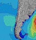 |  |  | 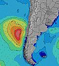 | 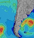 | 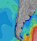 | 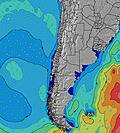 | ||||||||||||||
Wave Height (m) Direction Period (s) | SW 10 | SW 13 | SW 12 | SW 12 | SW 12 | SW 12 | SW 12 | SW 12 | SW 12 | SW 13 | SW 13 | SW 14 | SW 14 | SW 13 | SW 13 | SW 10 | SW 9 | SW 10 | SW 9 | SW 10 | SW 13 |
Wave Graph | |||||||||||||||||||||
154 | 653 | 827 | 736 | 736 | 748 | 761 | 689 | 614 | 572 | 710 | 1187 | 970 | 767 | 374 | 334 | 343 | 432 | 338 | 452 | 700 | |
Wind (km/h) | |||||||||||||||||||||
Wind State on-shore cross-onshore cross-shore cross-offshore off-shore glassy | cross-on | glassy | cross-off | cross | glassy | glassy | on | glassy | cross-on | cross-on | glassy | glassy | on | glassy | glassy | cross-on | cross-on | cross-on | on | cross-on | cross-on |
High Tide | 12:04PM1.19m | 00:53AM1.03m | 12:42PM1.10m | 1:42AM1.07m | 1:27PM1.01m | 2:41AM1.12m | 2:25PM0.91m | 3:47AM1.17m | 3:41PM0.84m | 4:57AM1.25m | 5:07PM0.81m | 6:02AM1.33m | 6:24PM0.82m | ||||||||
Low Tide | 6:41PM0.36m | 6:39AM0.53m | 7:14PM0.38m | 7:42AM0.57m | 7:53PM0.40m | 9:03AM0.59m | 8:41PM0.41m | 10:36AM0.57m | 9:42PM0.42m | 12:01PM0.51m | 10:51PM0.40m | 1:08PM0.43m | 11:58PM0.37m | ||||||||
7:09 | — | — | 7:09 | — | — | 7:07 | — | — | 7:07 | — | — | 7:07 | — | — | 7:05 | — | — | 7:05 | — | — | |
— | 6:23 | — | — | 6:23 | — | — | 6:23 | — | — | 6:24 | — | — | 6:24 | — | — | 6:24 | — | — | 6:25 | — | |
mm | — | — | — | — | — | — | — | — | — | — | — | — | — | — | — | — | — | — | — | — | — |
Temp °C | 19 | 19 | 17 | 18 | 18 | 18 | 20 | 20 | 18 | 19 | 19 | 17 | 18 | 18 | 16 | 19 | 19 | 16 | 18 | 18 | 17 |
Feels °C | 19 | 19 | 19 | 18 | 18 | 19 | 20 | 21 | 19 | 19 | 19 | 18 | 18 | 18 | 17 | 18 | 18 | 16 | 17 | 18 | 16 |
Swell 1 Height (m) Direction Period (s) | SW 10 | SW 13 | SW 12 | SW 12 | SW 12 | SW 12 | SW 12 | SW 12 | SW 12 | SW 13 | SW 13 | SW 14 | SW 14 | SW 13 | SW 13 | SW 10 | SW 9 | SW 10 | SW 9 | SW 10 | SW 13 |
154 | 653 | 827 | 736 | 736 | 748 | 761 | 689 | 614 | 572 | 710 | 1187 | 970 | 767 | 374 | 334 | 343 | 432 | 338 | 452 | 700 | |
Swell 2 Height (m) Direction Period (s) | SSW 12 | SSW 12 | W 12 | W 12 | SW 20 | SSW 21 | SW 20 | SW 19 | SW 18 | SW 16 | SW 16 | W 11 | — | — | SW 8 | SW 13 | SW 12 | SW 16 | SW 15 | SW 14 | SSW 9 |
123 | 28 | 3 | 3 | 16 | 42 | 60 | 131 | 304 | 421 | 560 | 2 | — | — | 158 | 108 | 146 | 155 | 301 | 238 | 295 | |
Swell 3 Height (m) Direction Period (s) | WSW 12 | W 12 | — | — | W 12 | W 11 | NW 12 | W 12 | W 12 | W 11 | W 11 | — | — | — | SW 19 | SW 18 | SW 16 | SW 12 | SW 11 | SW 20 | SW 19 |
60 | 3 | — | — | 3 | 2 | 6 | 3 | 3 | 2 | 2 | — | — | — | 14 | 49 | 94 | 52 | 71 | 60 | 92 | |
Wind waves Height (m) Direction Period (s) | — | — | — | — | — | — | — | — | — | — | — | — | — | — | — | — | — | — | — | — | — |
— | — | — | — | — | — | — | — | — | — | — | — | — | — | — | — | — | — | — | — | — | |
Nearest Offshore or Glassy | |||||||||||||||||||||
Distance (km) | 1 | 0 | 0 | 1 | 0 | 0 | 1 | 0 | 1 | 1 | 0 | 0 | 1 | 0 | 0 | 1 | 1 | 1 | 1 | 1 | 1 |
Best forecast wave conditions in Tarapaca | |||||||||||||||||||||
Best forecast wave conditions in Chile | |||||||||||||||||||||
Header Global | |||||||||||||||||||||
- Map Icons:
 Break
Break Live Wave Height (m)
 Live Wind Speed (km/h)
 Surf Rating (10 Max)
 Ocean Swells (m)
- Wind Speed (km/h)
Latest Updates


FREE! Surf-Forecast.com widget for your website
The surf report / weather widget below is available to embed on third party websites free of charge and provides a summary of our Las Urracas surf forecast. Simply grab the html code snippet that we provide and paste it into your own site. You can choose your preferred language and metric/imperial units for the surf forecast feed to suit users of your site. Click here to get the code.
Information about the Las Urracas Surf forecast
The above surf forecast table for Las Urracas provides essential information for determining whether the surfing conditions will be good over the next 16 days. A general guide to surfing at Las Urracas can be found by selecting the local surf guide option on the grey menu. Our Las Urracas surf forecast is unique since it includes wave energy (power) that defines the real feel of the surf rather than just the height or the period. If you surf the same spot (Las Urracas) regularly then make a mental note of the wave energy from the surf forecast table each time you go. Very soon you may start to choose your surf days based on the wave energy alone combined with our forecast of favourable offshore wind conditions. Our star ratings will help here and of course you will also find the usual wave height and period predictions on our surf forecasts as well as a full break down of the swell components under our advanced users option (to reveal that, click the little Einstein character under the tide times).
Further information to help with frequently asked questions about our surf forecast for Las Urracas may be found under the help tab on the top menu and also by moving your mouse over the question marks on the surf forecast table itself. Please always bear in mind that the forecast is for near-shore open water and local factors at each surf break influence the actual breaking wave height, such as the beach / reef profile, water depths offshore and shelter.
Are you planning a holiday in Tarapaca? If you are looking for accommodation near Las Urracas, camping, hotels and holiday cottages in Tarapaca, consider staying in Iquique which is 4 km (2 miles) away. Alternatively, find information about places to stay and car hire in Patillos which is 58 km (36 miles) away
 Nearest