

- Forecast
- Maps
- Live
- Weather State
- Spot Information

Seignosse - Les Bourdaines surfForecast / Landes / France
How big are the waves at Seignosse - Les Bourdaines today?
The current surf forecast for Seignosse - Les Bourdaines at 5AM is: 1.8m 14s primary swell from a West-northwest direction and 1.3m 6s secondary swell from a Northwest direction (forecast issued at 01:00am April 26). The wind direction is predicted to be onshore and the swell rating is 2.
| Time (CEST) & Date | Wave Height | Wave Period |
|---|---|---|
| Morning (26 Apr) | 6ft (1.9m) | 14s |
| Afternoon (26 Apr) | 6.5ft (2.0m) | 13s |
| Evening (26 Apr) | 5ft (1.6m) | 13s |
Table - waves today at Seignosse - Les Bourdaines. (Swell directed towards the surf break)
Saturday 26 | Sunday 27 | Monday 28 | Tuesday 29 | Wednesday 30 | Thursday 01 | Friday 02 | Saturday 03 | |||||||||||||||||||||||||||||||||||||||||||||||||||||
| 11 PM | 2 AM | 5 AM | 8 AM | 11 AM | 2 PM | 5 PM | 8 PM | 11 PM | 2 AM | 5 AM | 8 AM | 11 AM | 2 PM | 5 PM | 8 PM | 11 PM | 2 AM | 5 AM | 8 AM | 11 AM | 2 PM | 5 PM | 8 PM | 11 PM | 2 AM | 5 AM | 8 AM | 11 AM | 2 PM | 5 PM | 8 PM | 11 PM | 2 AM | 5 AM | 8 AM | 11 AM | 2 PM | 5 PM | 8 PM | 11 PM | 2 AM | 5 AM | 8 AM | 11 AM | 2 PM | 5 PM | 8 PM | 11 PM | 2 AM | 5 AM | 8 AM | 11 AM | 2 PM | 5 PM | 8 PM | 11 PM | 2 AM | 5 AM | 8 AM | |
Rating (10 max) | ||||||||||||||||||||||||||||||||||||||||||||||||||||||||||||
Swell Height Map |  |    |    |    |    |   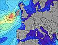 |  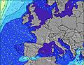 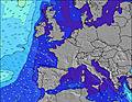 |  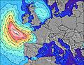 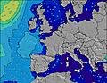 | 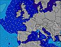 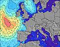 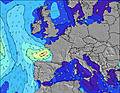 | |||||||||||||||||||||||||||||||||||||||||||||||||||
| Wave Height (m) & direction (?) | ||||||||||||||||||||||||||||||||||||||||||||||||||||||||||||
| Period(s) (?) | 14 | 14 | 14 | 14 | 14 | 13 | 13 | 13 | 13 | 13 | 12 | 12 | 12 | 12 | 12 | 12 | 11 | 11 | 11 | 11 | 11 | 11 | 11 | 11 | 11 | 10 | 10 | 10 | 10 | 10 | 10 | 10 | 10 | 10 | 9 | 12 | 12 | 11 | 13 | 12 | 12 | 12 | 12 | 11 | 11 | 11 | 11 | 10 | 10 | 10 | 10 | 10 | 10 | 9 | 15 | 14 | 13 | 13 | 12 | 12 |
Wave (?)Graph | ||||||||||||||||||||||||||||||||||||||||||||||||||||||||||||
| Energy (?) | 1423 | 1189 | 1207 | 1284 | 1419 | 1535 | 1042 | 811 | 703 | 692 | 639 | 609 | 599 | 589 | 833 | 677 | 560 | 486 | 435 | 443 | 435 | 419 | 366 | 334 | 275 | 260 | 194 | 198 | 146 | 143 | 140 | 109 | 98 | 71 | 45 | 51 | 127 | 140 | 108 | 101 | 230 | 222 | 215 | 193 | 190 | 149 | 143 | 141 | 160 | 100 | 76 | 117 | 92 | 86 | 104 | 123 | 144 | 326 | 268 | 209 |
Wind (km/h) | ||||||||||||||||||||||||||||||||||||||||||||||||||||||||||||
| Wind State (?) onshore cross-onshore cross-shore cross-offshore offshore glassy | on | cross- on | on | on | cross- on | on | cross- on | cross- on | cross- on | cross- on | cross- on | cross- on | cross- on | cross- on | cross- on | on | cross- on | glass | cross- off | cross- off | off | cross- off | cross- off | off | off | off | off | cross- off | cross- off | glass | off | off | off | off | off | off | cross- off | off | off | off | off | cross- off | cross- off | cross- off | cross | glass | cross- off | cross- off | off | cross- off | cross- off | off | off | off | off | off | off | off | off | off |
High Tide / height (m) | 3:55AM 3.89 | 4:23PM 3.83 | 4:41AM 4.09 | 5:06PM 4.02 | 5:26AM 4.17 | 5:48PM 4.10 | 6:12AM 4.11 | 6:32PM 4.07 | 6:59AM 3.92 | 7:17PM 3.92 | 7:48AM 3.64 | 8:06PM 3.68 | 8:42AM 3.30 | 9:02PM 3.40 | ||||||||||||||||||||||||||||||||||||||||||||||
Low Tide / height (m) | 9:38PM 0.29 | 10:06AM -0.03 | 10:23PM 0.01 | 10:49AM -0.18 | 11:08PM -0.17 | 11:32AM -0.20 | 11:53PM -0.23 | 12:15PM -0.10 | 12:39AM -0.16 | 12:59PM 0.11 | 1:27AM 0.04 | 1:46PM 0.39 | 2:19AM 0.33 | 2:37PM 0.70 | 3:18AM 0.65 | |||||||||||||||||||||||||||||||||||||||||||||
Saturday 26 | Sunday 27 | Monday 28 | Tuesday 29 | Wednesday 30 | Thursday 01 | Friday 02 | Saturday 03 | |||||||||||||||||||||||||||||||||||||||||||||||||||||
| Sunrise | - | - | - | 7:05 | - | - | - | - | - | - | - | 7:03 | - | - | - | - | - | - | - | 7:03 | - | - | - | - | - | - | - | 7:01 | - | - | - | - | - | - | - | 7:00 | - | - | - | - | - | - | - | 6:58 | - | - | - | - | - | - | - | 6:56 | - | - | - | - | - | - | - | 6:56 |
| Sunset | - | - | - | - | - | - | - | 9:00 | - | - | - | - | - | - | - | 9:01 | - | - | - | - | - | - | - | 9:04 | - | - | - | - | - | - | - | 9:05 | - | - | - | - | - | - | - | 9:06 | - | - | - | - | - | - | - | 9:07 | - | - | - | - | - | - | - | 9:07 | - | - | - | - |
Rain (mm) | - | 3 | 1 | 1 | 2 | 2 | 2 | 2 | 4 | 4 | 2 | 1 | 1 | 1 | 1 | - | - | - | - | - | - | - | - | - | - | - | - | - | - | - | - | - | - | - | - | - | - | - | - | - | - | - | - | - | - | - | - | - | - | - | - | - | - | - | - | - | - | - | - | - |
| Temp. °C | 14 | 12 | 13 | 13 | 13 | 14 | 13 | 12 | 13 | 12 | 13 | 13 | 13 | 14 | 14 | 14 | 14 | 13 | 12 | 12 | 16 | 21 | 23 | 22 | 20 | 18 | 16 | 15 | 19 | 23 | 25 | 23 | 19 | 16 | 15 | 14 | 19 | 24 | 24 | 24 | 20 | 18 | 16 | 15 | 18 | 23 | 24 | 24 | 23 | 19 | 18 | 17 | 21 | 26 | 27 | 25 | 23 | 21 | 20 | 19 |
| Feels °C (?) | 9 | 8 | 11 | 12 | 9 | 9 | 8 | 7 | 10 | 9 | 11 | 11 | 11 | 12 | 12 | 13 | 13 | 13 | 11 | 10 | 13 | 19 | 21 | 20 | 18 | 16 | 14 | 12 | 17 | 22 | 23 | 21 | 17 | 14 | 13 | 12 | 17 | 23 | 23 | 24 | 19 | 17 | 14 | 13 | 16 | 23 | 22 | 23 | 22 | 19 | 18 | 16 | 20 | 25 | 25 | 23 | 21 | 19 | 19 | 18 |
- Map Icons:
 Break
Break Live Wave Height (m)
 Live Wind Speed (km/h)
 Surf Rating (10 Max)
 Ocean Swells (m)
- Wind Speed (km/h)
FREE! Surf-Forecast.com widget for your website
The surf report / weather widget below is available to embed on third party websites free of charge and provides a summary of our Seignosse - Les Bourdaines surf forecast. Simply grab the html code snippet that we provide and paste it into your own site. You can choose your preferred language and metric/imperial units for the surf forecast feed to suit users of your site. Click here to get the code.


 Nearest