

- Forecast
- Maps
- Live
- Weather State
- Spot Information


Lorient surfForecast / Saint Barthélemy / Saint Barthélemy
How big are the waves at Lorient today?
The current surf forecast for Lorient at 11AM is: 0.9m 8s primary swell from a East-northeast direction and 0.4m 8s secondary swell from a Northwest direction, 0.8m 8s secondary swell from a East-southeast direction (forecast issued at 07:00am April 19). The wind direction is predicted to be cross-offshore.
| Time (AST) & Date | Wave Height | Wave Period |
|---|---|---|
| Morning (19 Apr) | 3ft (0.9m) | 8s |
| Afternoon (19 Apr) | 3ft (0.9m) | 8s |
| Evening (19 Apr) | 3ft (0.9m) | 8s |
Table - waves today at Lorient. (Swell directed towards the surf break)
Saturday 19 | Sunday 20 | Monday 21 | Tuesday 22 | Wednesday 23 | Thursday 24 | Friday 25 | Saturday 26 | |||||||||||||||||||||||||||||||||||||||||||||||||||||
| 5 AM | 8 AM | 11 AM | 2 PM | 5 PM | 8 PM | 11 PM | 2 AM | 5 AM | 8 AM | 11 AM | 2 PM | 5 PM | 8 PM | 11 PM | 2 AM | 5 AM | 8 AM | 11 AM | 2 PM | 5 PM | 8 PM | 11 PM | 2 AM | 5 AM | 8 AM | 11 AM | 2 PM | 5 PM | 8 PM | 11 PM | 2 AM | 5 AM | 8 AM | 11 AM | 2 PM | 5 PM | 8 PM | 11 PM | 2 AM | 5 AM | 8 AM | 11 AM | 2 PM | 5 PM | 8 PM | 11 PM | 2 AM | 5 AM | 8 AM | 11 AM | 2 PM | 5 PM | 8 PM | 11 PM | 2 AM | 5 AM | 8 AM | 11 AM | 2 PM | |
Rating (10 max) | ||||||||||||||||||||||||||||||||||||||||||||||||||||||||||||
Swell Height Map |    |    |    |  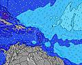 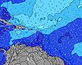 |  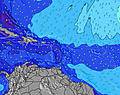 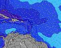 |  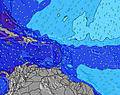 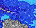 |  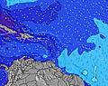 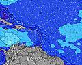 | 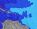 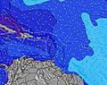 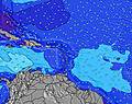 | ||||||||||||||||||||||||||||||||||||||||||||||||||||
| Wave Height (m) & direction (?) | ||||||||||||||||||||||||||||||||||||||||||||||||||||||||||||
| Period(s) (?) | 8 | 8 | 8 | 8 | 8 | 8 | 8 | 8 | 8 | 9 | 9 | 8 | 8 | 8 | 8 | 8 | 8 | 9 | 9 | 9 | 9 | 9 | 9 | 9 | 9 | 9 | 9 | 8 | 8 | 8 | 8 | 8 | 8 | 8 | 8 | 8 | 8 | 8 | 8 | 8 | 8 | 8 | 8 | 8 | 8 | 8 | 8 | 7 | 7 | 8 | 8 | 7 | 8 | 8 | 7 | 7 | 7 | 7 | 7 | 7 |
Wave (?)Graph | ||||||||||||||||||||||||||||||||||||||||||||||||||||||||||||
| Energy (?) | 133 | 85 | 89 | 85 | 107 | 116 | 116 | 131 | 146 | 158 | 180 | 184 | 246 | 270 | 270 | 273 | 273 | 334 | 349 | 351 | 351 | 359 | 364 | 318 | 306 | 258 | 257 | 241 | 196 | 160 | 136 | 136 | 138 | 140 | 113 | 111 | 228 | 257 | 326 | 299 | 291 | 256 | 249 | 255 | 255 | 222 | 290 | 330 | 340 | 320 | 358 | 349 | 320 | 283 | 276 | 279 | 303 | 303 | 315 | 343 |
Wind (km/h) | ||||||||||||||||||||||||||||||||||||||||||||||||||||||||||||
| Wind State (?) onshore cross-onshore cross-shore cross-offshore offshore glassy | cross- off | cross- off | cross- off | cross- off | cross- off | cross- off | cross- off | cross | cross- off | cross | cross | cross | cross- on | cross- on | cross- on | cross- on | cross- on | cross- on | cross- on | cross- on | cross- on | cross- on | cross- on | cross- on | cross- on | cross | cross | cross | cross | cross | cross | cross | cross- off | cross- off | cross- off | cross- off | cross- off | cross- off | cross- off | cross- off | cross- off | cross- off | cross- off | off | cross- off | cross- off | cross- off | off | off | cross- off | cross- off | cross- off | cross- off | cross- off | cross- off | cross- off | cross- off | cross- off | cross- off | cross- off |
High Tide / height (m) | 2:26AM 0.47 | 2:54AM 0.47 | 3:07AM 0.46 | 3:18AM 0.44 | 12:39PM 0.37 | 3:28AM 0.42 | 2:35PM 0.40 | 3:37AM 0.40 | 4:01PM 0.44 | 3:45AM 0.39 | 5:18PM 0.49 | 3:53AM 0.39 | ||||||||||||||||||||||||||||||||||||||||||||||||
Low Tide / height (m) | 5:22PM 0.02 | 6:31PM 0.03 | 7:38PM 0.05 | 10:02AM 0.35 | 8:42PM 0.09 | 9:43AM 0.27 | 9:44PM 0.14 | 10:09AM 0.17 | 10:44PM 0.20 | 10:45AM 0.07 | 11:43PM 0.28 | 11:27AM -0.03 | ||||||||||||||||||||||||||||||||||||||||||||||||
Saturday 19 | Sunday 20 | Monday 21 | Tuesday 22 | Wednesday 23 | Thursday 24 | Friday 25 | Saturday 26 | |||||||||||||||||||||||||||||||||||||||||||||||||||||
| Sunrise | - | 5:52 | - | - | - | - | - | - | - | 5:50 | - | - | - | - | - | - | - | 5:50 | - | - | - | - | - | - | - | 5:50 | - | - | - | - | - | - | - | 5:48 | - | - | - | - | - | - | - | 5:48 | - | - | - | - | - | - | - | 5:48 | - | - | - | - | - | - | - | 5:47 | - | - |
| Sunset | - | - | - | - | 6:28 | - | - | - | - | - | - | - | 6:29 | - | - | - | - | - | - | - | 6:29 | - | - | - | - | - | - | - | 6:29 | - | - | - | - | - | - | - | 6:29 | - | - | - | - | - | - | - | 6:30 | - | - | - | - | - | - | - | 6:30 | - | - | - | - | - | - | - |
Rain (mm) | 3 | 3 | - | 1 | - | - | 1 | 2 | 1 | - | - | 1 | - | - | 3 | - | - | - | - | - | - | - | - | - | - | - | - | - | - | - | - | - | - | - | - | - | - | - | - | - | - | - | 1 | 2 | 2 | 6 | 6 | 1 | - | 3 | 2 | 1 | - | - | - | 1 | 2 | - | - | - |
| Temp. °C | 25 | 25 | 25 | 26 | 26 | 26 | 25 | 25 | 25 | 25 | 25 | 25 | 25 | 25 | 25 | 25 | 25 | 25 | 25 | 25 | 25 | 25 | 25 | 24 | 24 | 25 | 25 | 25 | 25 | 25 | 25 | 24 | 24 | 24 | 24 | 25 | 25 | 25 | 25 | 25 | 25 | 25 | 25 | 25 | 25 | 24 | 24 | 24 | 25 | 24 | 24 | 24 | 24 | 24 | 24 | 24 | 25 | 25 | 25 | 26 |
| Feels °C (?) | 26 | 25 | 25 | 27 | 26 | 26 | 25 | 25 | 25 | 26 | 26 | 26 | 25 | 26 | 24 | 25 | 24 | 24 | 24 | 24 | 23 | 24 | 24 | 23 | 23 | 24 | 25 | 26 | 25 | 25 | 26 | 25 | 26 | 25 | 25 | 27 | 27 | 26 | 27 | 27 | 26 | 26 | 26 | 26 | 25 | 24 | 24 | 24 | 26 | 23 | 22 | 22 | 22 | 22 | 21 | 22 | 24 | 24 | 24 | 25 |
- Map Icons:
 Break
Break Live Wave Height (m)
 Live Wind Speed (km/h)
 Surf Rating (10 Max)
 Ocean Swells (m)
- Wind Speed (km/h)
FREE! Surf-Forecast.com widget for your website
The surf report / weather widget below is available to embed on third party websites free of charge and provides a summary of our Lorient surf forecast. Simply grab the html code snippet that we provide and paste it into your own site. You can choose your preferred language and metric/imperial units for the surf forecast feed to suit users of your site. Click here to get the code.


 Nearest