

Mangue Seco Surf Forecast and Surf Reports
(Bahia – Norte, Brazil)
- Forecast
- Maps
- Live
- Weather State
- Spot Information
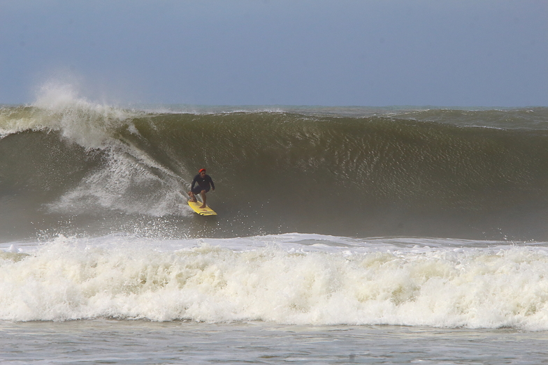 Photo by: Anacleto Junior
Mangue Seco Surf Guide
Mangue Seco in North Bahia is an exposed river break that has consistent surf. Winter is the best time of year for surfing here. Works best in offshore winds from the west northwest. Waves just as likely from local windswells as from distant groundswells and the best swell direction is from the southeast. Waves at the river break both left and right. Rarely crowded here. Surfing here means negotiating dangerous rips.
Mangue Seco Spot Info
| Type: | Rating: |
|---|---|
| Reliability: | Todays Sea Temp*: |
| consistent | 84°F*ocean temperature recorded from satellite |
Surfing Mangue Seco:
The best conditions reported for surf at Mangue Seco occur when a Southeast swell combines with an offshore wind direction from the West-northwest.
What's the best time of year to surf Mangue Seco (for consistent clean waves)?
Explore Mangue Seco Location Map
Interactive Mangue Seco surf break location map. View information about nearby surf breaks, their wave consistency and rating compared to other spots in the region. Current swell conditions from local buoys are shown along with live wind speed and direction from nearby weather stations. Click icons on the map for more detail. The nearest passenger airport to Mangue Seco is Santa Maria (Aracaju) Airport (AJU) in Brazil, which is 26 km (16 miles) away (directly). The second closest airport to Mangue Seco is Deputado Luis Eduardo Magalhaes (Salvador) Airport (SSA), also in Brazil, 229 km (142 miles) away.
- Map Icons:
 Break
Break Live Wave Height (ft)
 Live Wind Speed (mph)
 Surf Rating (10 Max)
 Ocean Swells (ft)
- Wind Speed (mph)
Wednesday, 26 March 2025, 08:21 Local Time
| Wednesday 26 | ||||
| 6AM | 9AM | 12PM | 3PM | |
| Wave (ft) | ||||
| Period (s) | 9 | 9 | 9 | 9 |
| Wind (mph) | ||||
| Wind State | cross- on |
cross- on |
on | on |
Tides at Mangue Seco
| NEXT | IS AT (local time) | remaining |
|---|---|---|
| high tide | ||
| low tide |
Swell History at Mangue Seco
Surf stats for Mangue Seco, see the swell variation by month or season on the history page here.


Wind History at Mangue Seco
Wind stats for Mangue Seco, see the variation in direction and stength by month or season on the history page here.

Mangue Seco Reviews:
Interactive Porthcawl Point location map. View nearby buoy information, live wind conditions and surrounding roads, paths and locations to help find new breaks. Click the buoys or wind icon to view more information.
- Overall:
 3.0
3.0 - Quality on a good day:
 3.5
3.5 - Consistency of Surf:4.0
- Difficulty Level:3.0
- Wind and Kite Surfing:
 1.0
1.0 - Crowds:3.5
Other Nearby Breaks Closest To:
Discover surf breaks near Mangue Seco. Click below to view there surf guides.
Wave Buoys Nearest To Mangue Seco:
- Closest Wave BuoyBrazil Buoy1622 mi
- Second closest Wave BuoyMiddle Atlantic Buoy1867 mi
- Third closest Wave BuoyWest Atlantic Buoy2080 mi
- Fourth closest Wave BuoyEast of Martinique Buoy2208 mi
- Fifth closest Wave BuoyEastern Caribbean Buoy2628 mi


 Nearest