

- Forecast
- Maps
- Live
- Weather State
- Spot Information
Narrabeen-Alley Rights Surf Forecast
/ NSW – Sydney North Coast (39 breaks) / New South Wales (297 breaks) /
Narrabeen-Alley Rights surfForecast / NSW – Sydney North Coast / Australia
How big are the waves at Narrabeen-Alley Rights today?
The current surf forecast for Narrabeen-Alley Rights at 5AM is: 5.0m 11s primary swell from a South-southeast direction and 0.4m 9s secondary swell from a East-northeast direction, 0.5m 10s secondary swell from a East direction (forecast issued at 10:00pm March 31). The wind direction is predicted to be cross-shore and the swell rating is 11.
| Time (AEDT) & Date | Wave Height | Wave Period |
|---|---|---|
| Morning (01 Apr) | 16ft (5.0m) | 12s |
| Afternoon (01 Apr) | 16ft (5.0m) | 13s |
| Evening (01 Apr) | 16ft (5.0m) | 13s |
Table - waves today at Narrabeen-Alley Rights. (Swell directed towards the surf break)
Mon 31 | Tuesday 01 | Wednesday 02 | Thursday 03 | Friday 04 | Saturday 05 | Sunday 06 | Monday 07 | Tue 08 | ||||||||||||||||||||||||||||||||||||||||||||||||||||
| 8 PM | 11 PM | 2 AM | 5 AM | 8 AM | 11 AM | 2 PM | 5 PM | 8 PM | 11 PM | 2 AM | 5 AM | 8 AM | 11 AM | 2 PM | 5 PM | 8 PM | 11 PM | 2 AM | 5 AM | 8 AM | 11 AM | 2 PM | 5 PM | 8 PM | 11 PM | 2 AM | 5 AM | 8 AM | 11 AM | 2 PM | 5 PM | 8 PM | 11 PM | 2 AM | 5 AM | 8 AM | 11 AM | 2 PM | 5 PM | 8 PM | 11 PM | 2 AM | 5 AM | 8 AM | 11 AM | 2 PM | 5 PM | 8 PM | 11 PM | 2 AM | 5 AM | 8 AM | 11 AM | 2 PM | 5 PM | 8 PM | 11 PM | 2 AM | 5 AM | |
Rating (10 max) | ||||||||||||||||||||||||||||||||||||||||||||||||||||||||||||
Swell Height Map |   |    |    |   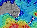 |  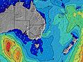 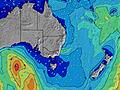 |  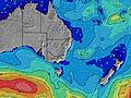 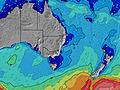 |  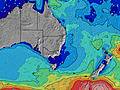 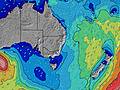 |  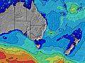 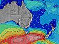 | 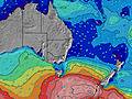 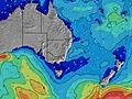 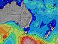 | |||||||||||||||||||||||||||||||||||||||||||||||||||
| Wave Height (m) & direction (?) | ||||||||||||||||||||||||||||||||||||||||||||||||||||||||||||
| Period(s) (?) | 10 | 9 | 11 | 11 | 12 | 12 | 13 | 13 | 13 | 13 | 13 | 12 | 12 | 12 | 12 | 12 | 11 | 11 | 11 | 10 | 10 | 10 | 10 | 10 | 14 | 9 | 14 | 9 | 9 | 13 | 8 | 8 | 8 | 8 | 8 | 8 | 8 | 8 | 9 | 5 | 8 | 8 | 9 | 9 | 9 | 10 | 10 | 9 | 9 | 9 | 9 | 9 | 8 | 8 | 6 | 6 | 8 | 11 | 11 | 11 |
Wave (?)Graph | ||||||||||||||||||||||||||||||||||||||||||||||||||||||||||||
| Energy (?) | 457 | 100 | 5042 | 5658 | 6500 | 7923 | 9096 | 8337 | 7784 | 8157 | 7742 | 5264 | 4366 | 3628 | 3043 | 2410 | 1988 | 1597 | 1237 | 919 | 692 | 615 | 527 | 443 | 348 | 292 | 250 | 239 | 184 | 181 | 157 | 153 | 116 | 92 | 92 | 71 | 67 | 68 | 23 | 80 | 24 | 24 | 24 | 14 | 15 | 16 | 17 | 16 | 15 | 6 | 6 | 6 | 42 | 47 | 52 | 61 | 24 | 3 | 3 | 3 |
Wind (km/h) | ||||||||||||||||||||||||||||||||||||||||||||||||||||||||||||
| Wind State (?) onshore cross-onshore cross-shore cross-offshore offshore glassy | cross- on | cross- on | cross | cross | cross | cross | cross- on | cross- on | cross- on | cross | cross- off | cross | cross- off | off | cross- off | cross | cross- off | cross- off | off | cross- off | cross- off | cross- off | on | on | cross- on | cross | cross- on | cross- on | cross- off | glass | cross- on | cross- on | cross | cross- off | cross- off | cross- off | cross- off | cross- off | cross- on | on | on | cross- on | cross- off | cross- off | off | off | glass | cross | cross- off | cross- off | cross- off | off | off | cross- off | cross- off | cross | cross- on | cross- on | cross- on | cross |
High Tide / height (m) | 10:46PM 1.68 | 11:17AM 1.30 | 11:32PM 1.66 | 12:12PM 1.16 | 12:23AM 1.59 | 1:16PM 1.03 | 1:22AM 1.51 | 2:32PM 0.95 | 2:31AM 1.42 | 3:58PM 0.93 | 3:47AM 1.36 | 5:15PM 0.97 | 5:00AM 1.35 | 6:12PM 1.05 | ||||||||||||||||||||||||||||||||||||||||||||||
Low Tide / height (m) | 5:15AM 0.04 | 5:06PM 0.19 | 6:12AM 0.09 | 5:51PM 0.31 | 7:15AM 0.17 | 6:42PM 0.42 | 8:28AM 0.25 | 7:45PM 0.51 | 9:46AM 0.29 | 9:05PM 0.57 | 11:00AM 0.30 | 10:30PM 0.56 | 11:58AM 0.28 | 11:41PM 0.52 | ||||||||||||||||||||||||||||||||||||||||||||||
Mon 31 | Tuesday 01 | Wednesday 02 | Thursday 03 | Friday 04 | Saturday 05 | Sunday 06 | Monday 07 | Tue 08 | ||||||||||||||||||||||||||||||||||||||||||||||||||||
| Sunrise | - | - | - | - | 7:05 | - | - | - | - | - | - | - | 7:05 | - | - | - | - | - | - | - | 7:07 | - | - | - | - | - | - | - | 7:07 | - | - | - | - | - | - | - | 7:09 | - | - | - | - | - | - | - | 7:09 | - | - | - | - | - | - | - | 7:09 | - | - | - | - | - | - | - |
| Sunset | - | - | - | - | - | - | - | 6:51 | - | - | - | - | - | - | - | 6:49 | - | - | - | - | - | - | - | 6:47 | - | - | - | - | - | - | - | 6:46 | - | - | - | - | - | - | - | 6:45 | - | - | - | - | - | - | - | 6:44 | - | - | - | - | - | - | - | 6:43 | - | - | - | - |
Rain (mm) | 1 | 1 | 1 | 1 | 1 | 1 | - | - | - | - | - | - | - | - | - | - | - | - | - | - | - | - | - | - | - | - | - | - | - | - | - | - | - | - | - | - | - | - | - | - | - | - | - | - | - | - | - | - | - | - | - | - | - | - | - | - | - | - | - | - |
| Temp. °C | 20 | 20 | 19 | 18 | 18 | 19 | 20 | 20 | 20 | 19 | 16 | 16 | 16 | 17 | 22 | 22 | 21 | 19 | 18 | 16 | 16 | 21 | 24 | 22 | 21 | 20 | 20 | 19 | 18 | 20 | 22 | 22 | 21 | 21 | 19 | 17 | 17 | 22 | 25 | 22 | 19 | 19 | 17 | 16 | 15 | 20 | 24 | 23 | 22 | 20 | 18 | 17 | 18 | 23 | 25 | 23 | 19 | 18 | 17 | 15 |
| Feels °C (?) | 14 | 14 | 14 | 13 | 13 | 14 | 14 | 14 | 14 | 15 | 13 | 14 | 15 | 15 | 20 | 18 | 19 | 18 | 18 | 15 | 15 | 20 | 22 | 19 | 20 | 19 | 19 | 19 | 18 | 20 | 21 | 20 | 19 | 20 | 19 | 15 | 13 | 18 | 19 | 16 | 15 | 17 | 15 | 14 | 13 | 17 | 22 | 20 | 21 | 18 | 14 | 12 | 12 | 16 | 18 | 15 | 14 | 12 | 10 | 8 |
- Map Icons:
 Break
Break Live Wave Height (m)
 Live Wind Speed (km/h)
 Surf Rating (10 Max)
 Ocean Swells (m)
- Wind Speed (km/h)
FREE! Surf-Forecast.com widget for your website
The surf report / weather widget below is available to embed on third party websites free of charge and provides a summary of our Narrabeen-Alley Rights surf forecast. Simply grab the html code snippet that we provide and paste it into your own site. You can choose your preferred language and metric/imperial units for the surf forecast feed to suit users of your site. Click here to get the code.


 Nearest