

- Forecast
- Maps
- Live
- Weather State
- Spot Information

Surf Forecasts
Noordhoek surfForecast / Eastern Cape (S) / South Africa
Forecast update in hr min s Forecast update imminent
Noordhoek surf forecast is for near shore open water. Breaking waves will often be smaller at less exposed spots.
Today's Noordhoek sea temperature is
18.6° C
(Which is 3.5°C colder than average for this time of year)How big are the waves at Noordhoek today?
The current surf forecast for Noordhoek at 1PM is: 1.6m 14s primary swell from a South-southwest direction (forecast issued at 07:00am April 07). An open ocean swell of 2.1m 9s is not directed at the surf break. The wind direction is predicted to be cross-onshore.
| Time (SAST) & Date | Wave Height | Wave Period |
|---|---|---|
| Morning (07 Apr) | 6ft (1.8m) | 14s |
| Afternoon (07 Apr) | 5ft (1.6m) | 14s |
| Evening (07 Apr) | 5ft (1.5m) | 13s |
Table - waves today at Noordhoek. (Swell directed towards the surf break)
Updates in hr min s Forecast update imminent
Monday 07 | Tuesday 08 | Wednesday 09 | Thursday 10 | Friday 11 | Saturday 12 | Sunday 13 | Monday 14 | |||||||||||||||||||||||||||||||||||||||||||||||||||||
| 5 AM | 8 AM | 11 AM | 2 PM | 5 PM | 8 PM | 11 PM | 2 AM | 5 AM | 8 AM | 11 AM | 2 PM | 5 PM | 8 PM | 11 PM | 2 AM | 5 AM | 8 AM | 11 AM | 2 PM | 5 PM | 8 PM | 11 PM | 2 AM | 5 AM | 8 AM | 11 AM | 2 PM | 5 PM | 8 PM | 11 PM | 2 AM | 5 AM | 8 AM | 11 AM | 2 PM | 5 PM | 8 PM | 11 PM | 2 AM | 5 AM | 8 AM | 11 AM | 2 PM | 5 PM | 8 PM | 11 PM | 2 AM | 5 AM | 8 AM | 11 AM | 2 PM | 5 PM | 8 PM | 11 PM | 2 AM | 5 AM | 8 AM | 11 AM | 2 PM | |
Rating (10 max) | ||||||||||||||||||||||||||||||||||||||||||||||||||||||||||||
Swell Height Map |    |    |    |   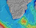 |  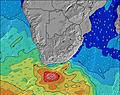 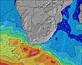 |  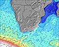 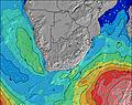 |  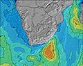 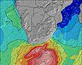 | 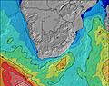 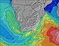 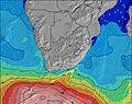 | ||||||||||||||||||||||||||||||||||||||||||||||||||||
| Wave Height (m) & direction (?) | ||||||||||||||||||||||||||||||||||||||||||||||||||||||||||||
| Period(s) (?) | 14 | 14 | 14 | 14 | 13 | 13 | 13 | 13 | 13 | 13 | 13 | 13 | 13 | 13 | 13 | 13 | 12 | 13 | 7 | 7 | 7 | 12 | 8 | 8 | 14 | 12 | 13 | 12 | 12 | 12 | 12 | 11 | 15 | 14 | 14 | 14 | 13 | 13 | 13 | 13 | 13 | 13 | 13 | 12 | 12 | 12 | 12 | 12 | 12 | 12 | 12 | 12 | 12 | 12 | 12 | 12 | 12 | 11 | 11 | 11 |
Wave (?)Graph | ||||||||||||||||||||||||||||||||||||||||||||||||||||||||||||
| Energy (?) | 1455 | 1301 | 1143 | 889 | 768 | 756 | 745 | 606 | 606 | 596 | 555 | 578 | 555 | 572 | 437 | 437 | 341 | 352 | 453 | 607 | 349 | 409 | 665 | 498 | 401 | 384 | 560 | 618 | 589 | 508 | 605 | 583 | 519 | 1560 | 1516 | 1411 | 1422 | 1497 | 1452 | 1430 | 1297 | 1297 | 1559 | 1342 | 1258 | 1483 | 1640 | 1520 | 1459 | 1323 | 1302 | 1125 | 964 | 789 | 735 | 575 | 565 | 504 | 458 | 517 |
Wind (km/h) | ||||||||||||||||||||||||||||||||||||||||||||||||||||||||||||
| Wind State (?) onshore cross-onshore cross-shore cross-offshore offshore glassy | cross | cross | cross | cross- on | cross- on | cross- on | cross- on | cross- on | cross- off | cross- off | cross- off | cross- off | cross- off | cross- off | cross- off | cross- off | cross- off | cross- off | cross- off | cross- off | cross- off | cross | cross- off | cross- off | cross- off | cross- off | cross | cross- on | on | cross- on | cross- on | cross- on | cross | cross | cross | cross- on | cross- on | cross- on | cross- off | cross- off | cross- off | cross- off | cross- off | cross | cross | cross | glass | glass | cross | glass | glass | cross- on | cross- on | cross- off | cross- off | cross | on | on | cross- on | cross- on |
High Tide / height (m) | 12:53PM 1.37 | 1:21AM 1.54 | 1:42PM 1.49 | 1:59AM 1.68 | 2:16PM 1.60 | 2:30AM 1.79 | 2:45PM 1.69 | 2:57AM 1.87 | 3:12PM 1.75 | 3:23AM 1.93 | 3:38PM 1.80 | 3:48AM 1.95 | 4:03PM 1.82 | 4:13AM 1.94 | ||||||||||||||||||||||||||||||||||||||||||||||
Low Tide / height (m) | 7:07AM 0.83 | 7:13PM 0.76 | 7:52AM 0.68 | 7:52PM 0.64 | 8:22AM 0.56 | 8:21PM 0.54 | 8:48AM 0.47 | 8:46PM 0.45 | 9:11AM 0.40 | 9:10PM 0.39 | 9:34AM 0.34 | 9:34PM 0.35 | 9:57AM 0.32 | 9:59PM 0.34 | 10:21AM 0.32 | |||||||||||||||||||||||||||||||||||||||||||||
Monday 07 | Tuesday 08 | Wednesday 09 | Thursday 10 | Friday 11 | Saturday 12 | Sunday 13 | Monday 14 | |||||||||||||||||||||||||||||||||||||||||||||||||||||
| Sunrise | - | 6:33 | - | - | - | - | - | - | - | 6:33 | - | - | - | - | - | - | - | 6:35 | - | - | - | - | - | - | - | 6:35 | - | - | - | - | - | - | - | 6:35 | - | - | - | - | - | - | - | 6:37 | - | - | - | - | - | - | - | 6:37 | - | - | - | - | - | - | - | 6:37 | - | - |
| Sunset | - | - | - | - | 6:05 | - | - | - | - | - | - | - | 6:02 | - | - | - | - | - | - | - | 6:01 | - | - | - | - | - | - | - | 6:00 | - | - | - | - | - | - | - | 6:00 | - | - | - | - | - | - | - | 5:58 | - | - | - | - | - | - | - | 5:57 | - | - | - | - | - | - | - |
Rain (mm) | - | - | - | - | - | - | - | - | - | 1 | 2 | - | 1 | 8 | 2 | - | - | - | - | 1 | 1 | 1 | 1 | - | - | - | - | - | - | - | - | - | - | - | - | - | - | - | - | - | - | - | - | - | - | - | - | - | - | - | - | - | - | 1 | - | 2 | 3 | - | 1 | - |
| Temp. °C | 20 | 20 | 23 | 25 | 23 | 23 | 23 | 22 | 21 | 19 | 19 | 19 | 19 | 19 | 19 | 19 | 19 | 19 | 21 | 19 | 20 | 21 | 20 | 19 | 18 | 18 | 19 | 19 | 19 | 19 | 19 | 19 | 18 | 19 | 20 | 22 | 22 | 22 | 21 | 19 | 17 | 17 | 19 | 19 | 19 | 19 | 19 | 19 | 19 | 20 | 21 | 21 | 21 | 21 | 18 | 18 | 19 | 20 | 18 | 18 |
| Feels °C (?) | 18 | 19 | 22 | 24 | 21 | 22 | 23 | 22 | 23 | 16 | 18 | 18 | 16 | 15 | 14 | 16 | 14 | 13 | 14 | 13 | 18 | 20 | 18 | 17 | 16 | 17 | 18 | 19 | 18 | 18 | 17 | 18 | 17 | 18 | 19 | 20 | 20 | 22 | 21 | 14 | 12 | 13 | 15 | 16 | 18 | 19 | 20 | 21 | 20 | 22 | 24 | 22 | 21 | 21 | 15 | 18 | 15 | 18 | 17 | 17 |
- Map Icons:
 Break
Break Live Wave Height (m)
 Live Wind Speed (km/h)
 Surf Rating (10 Max)
 Ocean Swells (m)
- Wind Speed (km/h)
FREE! Surf-Forecast.com widget for your website
The surf report / weather widget below is available to embed on third party websites free of charge and provides a summary of our Noordhoek surf forecast. Simply grab the html code snippet that we provide and paste it into your own site. You can choose your preferred language and metric/imperial units for the surf forecast feed to suit users of your site. Click here to get the code.


 Nearest