

- Forecast
- Maps
- Live
- Weather State
- Spot Information

Quintanilla surfForecast / Gran Canaria / Spain
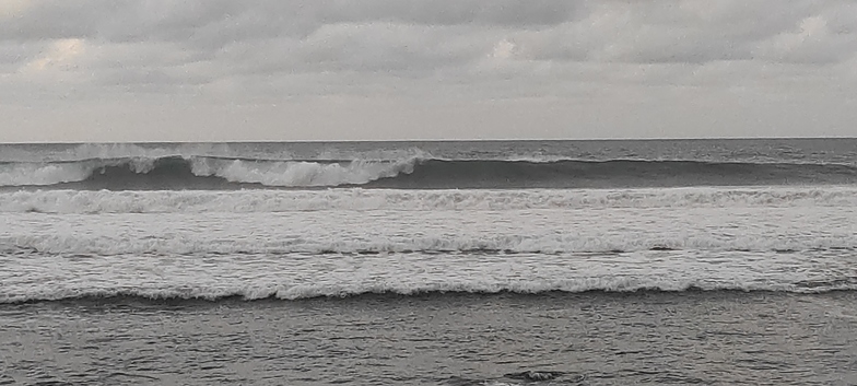
How big are the waves at Quintanilla today?
The current surf forecast for Quintanilla at 11PM is: 1.4m 8s primary swell from a North-northeast direction and 0.9m 12s secondary swell from a North-northwest direction, 0.1m 11s secondary swell from a North direction (forecast issued at 06:00pm April 27). The wind direction is predicted to be onshore.
| Time (WEST) & Date | Wave Height | Wave Period |
|---|---|---|
| Morning (27 Apr) | - | - |
| Afternoon (27 Apr) | 5ft (1.6m) | 8s |
| Evening (27 Apr) | 3.5ft (1.0m) | 12s |
Table - waves today at Quintanilla. (Swell directed towards the surf break)
Sunday 27 | Monday 28 | Tuesday 29 | Wednesday 30 | Thursday 01 | Friday 02 | Saturday 03 | Sunday 04 | Mon 05 | ||||||||||||||||||||||||||||||||||||||||||||||||||||
| 4 PM | 7 PM | 10 PM | 1 AM | 4 AM | 7 AM | 10 AM | 1 PM | 4 PM | 7 PM | 10 PM | 1 AM | 4 AM | 7 AM | 10 AM | 1 PM | 4 PM | 7 PM | 10 PM | 1 AM | 4 AM | 7 AM | 10 AM | 1 PM | 4 PM | 7 PM | 10 PM | 1 AM | 4 AM | 7 AM | 10 AM | 1 PM | 4 PM | 7 PM | 10 PM | 1 AM | 4 AM | 7 AM | 10 AM | 1 PM | 4 PM | 7 PM | 10 PM | 1 AM | 4 AM | 7 AM | 10 AM | 1 PM | 4 PM | 7 PM | 10 PM | 1 AM | 4 AM | 7 AM | 10 AM | 1 PM | 4 PM | 7 PM | 10 PM | 1 AM | |
Rating (10 max) | ||||||||||||||||||||||||||||||||||||||||||||||||||||||||||||
Swell Height Map |   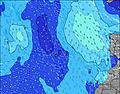 |  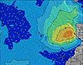 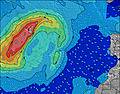 |  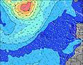 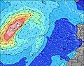 | 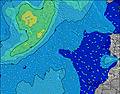 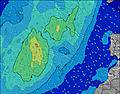 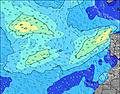 | 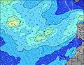  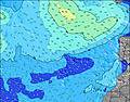 | 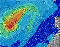 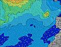 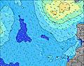 | 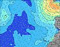 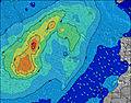  |  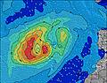  | 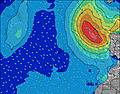 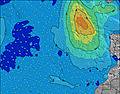 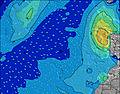 | |||||||||||||||||||||||||||||||||||||||||||||||||||
| Wave Height (m) & direction (?) | ||||||||||||||||||||||||||||||||||||||||||||||||||||||||||||
| Period(s) (?) | 8 | 8 | 8 | 8 | 8 | 11 | 11 | 11 | 7 | 7 | 7 | 7 | 10 | 5 | 11 | 5 | 6 | 6 | 7 | 9 | 10 | 10 | 11 | 11 | 11 | 11 | 11 | 11 | 12 | 12 | 13 | 13 | 13 | 13 | 13 | 13 | 12 | 12 | 12 | 11 | 11 | 11 | 10 | 10 | 10 | 10 | 9 | 9 | 9 | 9 | 8 | 13 | 8 | 12 | 12 | 12 | 11 | 7 | 7 | 11 |
Wave (?)Graph | ||||||||||||||||||||||||||||||||||||||||||||||||||||||||||||
| Energy (?) | 285 | 292 | 267 | 238 | 186 | 181 | 176 | 156 | 156 | 160 | 155 | 152 | 408 | 102 | 113 | 161 | 192 | 253 | 257 | 599 | 725 | 917 | 970 | 1006 | 1006 | 923 | 878 | 978 | 1412 | 1605 | 1974 | 2265 | 2507 | 2469 | 2558 | 2480 | 2151 | 1844 | 1597 | 1207 | 988 | 873 | 701 | 567 | 461 | 419 | 348 | 268 | 243 | 222 | 205 | 165 | 157 | 127 | 123 | 121 | 88 | 83 | 79 | 66 |
Wind (km/h) | ||||||||||||||||||||||||||||||||||||||||||||||||||||||||||||
| Wind State (?) onshore cross-onshore cross-shore cross-offshore offshore glassy | cross- on | on | on | on | on | on | on | on | on | on | on | cross- on | cross- on | cross- on | cross- on | cross- on | cross- on | cross- on | cross- on | cross- on | cross- on | cross- on | cross- on | cross- on | cross- on | cross- on | cross- on | cross- off | cross- off | cross- off | off | glass | cross- on | cross- on | on | glass | cross- on | cross- on | cross- on | cross- on | cross- on | cross- on | cross- on | cross- on | cross- on | on | on | on | on | on | cross- on | cross- on | cross- on | cross- on | cross- on | cross- on | cross- on | on | cross- on | cross- on |
High Tide / height (m) | 1:54PM 2.29 | 2:12AM 2.36 | 2:36PM 2.32 | 2:57AM 2.29 | 3:18PM 2.28 | 3:44AM 2.15 | 4:02PM 2.18 | 4:33AM 1.96 | 4:51PM 2.04 | 5:28AM 1.76 | 5:46PM 1.88 | 6:33AM 1.57 | 6:54PM 1.74 | 7:54AM 1.46 | 8:16PM 1.67 | |||||||||||||||||||||||||||||||||||||||||||||
Low Tide / height (m) | 7:59PM -0.04 | 8:22AM -0.09 | 8:43PM -0.07 | 9:03AM -0.01 | 9:28PM -0.02 | 9:46AM 0.13 | 10:17PM 0.10 | 10:31AM 0.31 | 11:10PM 0.26 | 11:21AM 0.49 | 12:13AM 0.44 | 12:22PM 0.66 | 1:33AM 0.57 | 1:44PM 0.76 | ||||||||||||||||||||||||||||||||||||||||||||||
Sunday 27 | Monday 28 | Tuesday 29 | Wednesday 30 | Thursday 01 | Friday 02 | Saturday 03 | Sunday 04 | Mon 05 | ||||||||||||||||||||||||||||||||||||||||||||||||||||
| Sunrise | - | - | - | - | - | - | 7:24 | - | - | - | - | - | - | - | 7:24 | - | - | - | - | - | - | - | 7:22 | - | - | - | - | - | - | - | 7:22 | - | - | - | - | - | - | - | 7:20 | - | - | - | - | - | - | - | 7:20 | - | - | - | - | - | - | - | 7:20 | - | - | - | - | - |
| Sunset | - | 8:34 | - | - | - | - | - | - | - | 8:34 | - | - | - | - | - | - | - | 8:35 | - | - | - | - | - | - | - | 8:35 | - | - | - | - | - | - | - | 8:36 | - | - | - | - | - | - | - | 8:37 | - | - | - | - | - | - | - | 8:37 | - | - | - | - | - | - | - | 8:37 | - | - |
Rain (mm) | - | - | - | - | - | - | - | - | - | - | - | - | - | - | - | - | - | - | - | - | - | - | - | - | - | - | - | - | - | - | - | - | - | - | - | - | - | - | - | - | - | - | - | - | - | - | - | - | - | - | - | - | - | - | - | - | - | - | - | - |
| Temp. °C | 19 | 18 | 17 | 17 | 17 | 16 | 17 | 19 | 19 | 19 | 18 | 17 | 17 | 17 | 18 | 18 | 18 | 18 | 17 | 17 | 16 | 16 | 17 | 18 | 18 | 18 | 18 | 18 | 17 | 17 | 18 | 20 | 20 | 20 | 19 | 19 | 18 | 18 | 19 | 20 | 20 | 19 | 19 | 18 | 17 | 17 | 18 | 19 | 19 | 19 | 18 | 17 | 17 | 17 | 17 | 19 | 19 | 18 | 17 | 17 |
| Feels °C (?) | 17 | 16 | 15 | 15 | 16 | 14 | 14 | 17 | 16 | 16 | 16 | 14 | 13 | 13 | 14 | 12 | 12 | 12 | 11 | 12 | 11 | 11 | 13 | 15 | 14 | 15 | 16 | 16 | 16 | 16 | 16 | 20 | 18 | 19 | 20 | 20 | 18 | 16 | 17 | 18 | 18 | 17 | 17 | 17 | 16 | 16 | 17 | 18 | 17 | 18 | 17 | 16 | 15 | 15 | 15 | 18 | 17 | 16 | 15 | 15 |
- Map Icons:
 Break
Break Live Wave Height (m)
 Live Wind Speed (km/h)
 Surf Rating (10 Max)
 Ocean Swells (m)
- Wind Speed (km/h)
FREE! Surf-Forecast.com widget for your website
The surf report / weather widget below is available to embed on third party websites free of charge and provides a summary of our Quintanilla surf forecast. Simply grab the html code snippet that we provide and paste it into your own site. You can choose your preferred language and metric/imperial units for the surf forecast feed to suit users of your site. Click here to get the code.


 Nearest