

- Forecast
- Maps
- Live
- Weather State
- Spot Information
Raglan-Indicators Surf Forecast
/ Raglan and West Waikato (8 surf breaks) /
Surf Forecasts
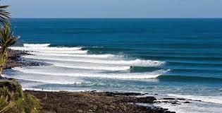
Raglan-Indicators surfForecast / Raglan and West Waikato / New Zealand
Forecast update in hr min s Forecast update imminent
Raglan-Indicators surf forecast is for near shore open water. Breaking waves will often be smaller at less exposed spots.
Today's Raglan-Indicators sea temperature is
19.4° C
(Which is 1.7°C warmer than normal for this time of year)How big are the waves at Raglan-Indicators today?
The current surf forecast for Raglan-Indicators at 3AM is: 1.7m 15s primary swell from a West-southwest direction (forecast issued at 11:00pm April 24). The wind direction is predicted to be cross-offshore and the swell rating is 4.
| Time (NZST) & Date | Wave Height | Wave Period |
|---|---|---|
| Morning (25 Apr) | 5ft (1.6m) | 15s |
| Afternoon (25 Apr) | 4.5ft (1.4m) | 14s |
| Evening (25 Apr) | 4.5ft (1.3m) | 14s |
Table - waves today at Raglan-Indicators. (Swell directed towards the surf break)
Updates in hr min s Forecast update imminent
Friday 25 | Saturday 26 | Sunday 27 | Monday 28 | Tuesday 29 | Wednesday 30 | Thursday 01 | Friday 02 | |||||||||||||||||||||||||||||||||||||||||||||||||||||
| 9 PM | 0 AM | 3 AM | 6 AM | 9 AM | 12 PM | 3 PM | 6 PM | 9 PM | 0 AM | 3 AM | 6 AM | 9 AM | 12 PM | 3 PM | 6 PM | 9 PM | 0 AM | 3 AM | 6 AM | 9 AM | 12 PM | 3 PM | 6 PM | 9 PM | 0 AM | 3 AM | 6 AM | 9 AM | 12 PM | 3 PM | 6 PM | 9 PM | 0 AM | 3 AM | 6 AM | 9 AM | 12 PM | 3 PM | 6 PM | 9 PM | 0 AM | 3 AM | 6 AM | 9 AM | 12 PM | 3 PM | 6 PM | 9 PM | 0 AM | 3 AM | 6 AM | 9 AM | 12 PM | 3 PM | 6 PM | 9 PM | 0 AM | 3 AM | 6 AM | |
Rating (10 max) | ||||||||||||||||||||||||||||||||||||||||||||||||||||||||||||
Swell Height Map |  |    |    |    |  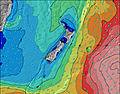 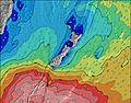 |  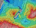 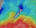 |  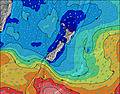 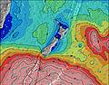 |  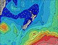 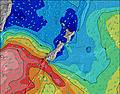 | 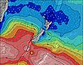 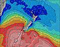 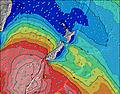 | |||||||||||||||||||||||||||||||||||||||||||||||||||
| Wave Height (m) & direction (?) | ||||||||||||||||||||||||||||||||||||||||||||||||||||||||||||
| Period(s) (?) | 15 | 15 | 15 | 15 | 15 | 14 | 14 | 14 | 14 | 14 | 14 | 14 | 14 | 14 | 14 | 13 | 13 | 13 | 16 | 16 | 16 | 15 | 15 | 14 | 14 | 14 | 14 | 13 | 17 | 16 | 16 | 16 | 15 | 15 | 15 | 14 | 14 | 14 | 14 | 14 | 14 | 14 | 14 | 14 | 14 | 13 | 13 | 13 | 13 | 12 | 12 | 12 | 12 | 12 | 12 | 12 | 12 | 12 | 12 | 12 |
Wave (?)Graph | ||||||||||||||||||||||||||||||||||||||||||||||||||||||||||||
| Energy (?) | 1241 | 1225 | 1193 | 1038 | 1024 | 899 | 845 | 732 | 668 | 561 | 561 | 561 | 545 | 460 | 447 | 440 | 265 | 215 | 575 | 715 | 697 | 636 | 706 | 687 | 659 | 622 | 604 | 506 | 772 | 1484 | 1611 | 1571 | 1358 | 1237 | 1091 | 1076 | 930 | 904 | 879 | 904 | 1076 | 996 | 822 | 811 | 653 | 624 | 536 | 528 | 402 | 309 | 304 | 226 | 180 | 177 | 121 | 117 | 119 | 121 | 121 | 158 |
Wind (km/h) | ||||||||||||||||||||||||||||||||||||||||||||||||||||||||||||
| Wind State (?) onshore cross-onshore cross-shore cross-offshore offshore glassy | cross- off | cross- off | cross- off | cross- off | cross- off | cross- off | cross- off | cross- off | cross- off | cross- off | cross- off | cross- off | cross- off | cross- off | cross- off | cross- off | cross- off | cross- off | cross- off | cross- off | cross- off | cross- off | cross- off | cross- off | cross- off | cross- off | cross- off | cross- off | cross- off | cross- off | cross- off | cross- off | cross- off | cross- off | cross- off | off | off | cross- off | cross- off | cross- off | cross- off | cross- off | glass | glass | glass | cross | cross | glass | cross- off | cross- off | off | cross- off | cross- off | glass | cross | cross- off | cross- off | cross | cross- off | cross- off |
High Tide / height (m) | 6:56PM 2.61 | 7:15AM 2.86 | 7:46PM 2.85 | 8:04AM 3.05 | 8:33PM 3.06 | 8:50AM 3.18 | 9:18PM 3.20 | 9:36AM 3.24 | 10:02PM 3.27 | 10:21AM 3.20 | 10:48PM 3.26 | 11:08AM 3.09 | 11:34PM 3.15 | 11:56AM 2.91 | 12:24AM 2.99 | |||||||||||||||||||||||||||||||||||||||||||||
Low Tide / height (m) | 1:00AM 0.40 | 1:32PM 0.17 | 1:52AM 0.20 | 2:19PM -0.03 | 2:40AM 0.03 | 3:05PM -0.16 | 3:28AM -0.08 | 3:51PM -0.20 | 4:16AM -0.10 | 4:37PM -0.15 | 5:04AM -0.03 | 5:24PM -0.02 | 5:54AM 0.11 | 6:13PM 0.16 | ||||||||||||||||||||||||||||||||||||||||||||||
Friday 25 | Saturday 26 | Sunday 27 | Monday 28 | Tuesday 29 | Wednesday 30 | Thursday 01 | Friday 02 | |||||||||||||||||||||||||||||||||||||||||||||||||||||
| Sunrise | - | - | - | - | 6:56 | - | - | - | - | - | - | - | 6:56 | - | - | - | - | - | - | - | 6:56 | - | - | - | - | - | - | - | 6:58 | - | - | - | - | - | - | - | 6:58 | - | - | - | - | - | - | - | 7:00 | - | - | - | - | - | - | - | 7:01 | - | - | - | - | - | - | - |
| Sunset | - | - | - | - | - | - | 5:40 | - | - | - | - | - | - | - | 5:39 | - | - | - | - | - | - | - | 5:37 | - | - | - | - | - | - | - | 5:37 | - | - | - | - | - | - | - | 5:36 | - | - | - | - | - | - | - | 5:35 | - | - | - | - | - | - | - | 5:34 | - | - | - | - | - |
Rain (mm) | - | - | - | - | - | - | - | - | - | - | - | - | - | - | - | - | - | - | - | - | - | - | - | - | - | - | - | - | - | - | - | - | - | - | - | - | - | - | - | - | - | - | - | - | - | - | - | - | - | - | - | - | - | - | - | - | - | - | - | - |
| Temp. °C | 15 | 14 | 13 | 13 | 13 | 16 | 17 | 16 | 15 | 14 | 14 | 15 | 15 | 17 | 17 | 16 | 16 | 16 | 16 | 15 | 16 | 20 | 21 | 19 | 16 | 15 | 15 | 15 | 16 | 21 | 21 | 19 | 17 | 15 | 15 | 14 | 16 | 21 | 21 | 18 | 17 | 16 | 15 | 15 | 16 | 18 | 19 | 18 | 17 | 14 | 14 | 13 | 15 | 18 | 18 | 16 | 15 | 14 | 13 | 13 |
| Feels °C (?) | 12 | 11 | 10 | 9 | 9 | 12 | 14 | 13 | 12 | 12 | 12 | 12 | 13 | 15 | 16 | 14 | 15 | 15 | 15 | 13 | 15 | 19 | 20 | 17 | 15 | 14 | 14 | 14 | 15 | 20 | 20 | 18 | 17 | 14 | 15 | 14 | 16 | 20 | 19 | 17 | 16 | 15 | 14 | 14 | 15 | 16 | 18 | 18 | 16 | 12 | 12 | 11 | 13 | 17 | 16 | 15 | 14 | 12 | 11 | 11 |
- Map Icons:
 Break
Break Live Wave Height (m)
 Live Wind Speed (km/h)
 Surf Rating (10 Max)
 Ocean Swells (m)
- Wind Speed (km/h)
FREE! Surf-Forecast.com widget for your website
The surf report / weather widget below is available to embed on third party websites free of charge and provides a summary of our Raglan-Indicators surf forecast. Simply grab the html code snippet that we provide and paste it into your own site. You can choose your preferred language and metric/imperial units for the surf forecast feed to suit users of your site. Click here to get the code.


 Nearest