

- Forecast
- Maps
- Live
- Weather State
- Spot Information

Surf Forecasts
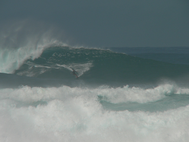
Tunnels surfForecast / HAW – Kaua'i / USA
Forecast update in hr min s Forecast update imminent
Tunnels surf forecast is for near shore open water. Breaking waves will often be smaller at less exposed spots.
Today's Tunnels sea temperature is
25.0° C
(Which is slightly warmer than usual)How big are the waves at Tunnels today?
The current surf forecast for Tunnels at 5AM is: 1.2m 11s primary swell from a North direction and 1.2m 7s secondary swell from a East direction (forecast issued at 01:00am April 19). The wind direction is predicted to be cross-offshore and the swell rating is 2.
| Time (HST) & Date | Wave Height | Wave Period |
|---|---|---|
| Morning (19 Apr) | 3.5ft (1.1m) | 11s |
| Afternoon (19 Apr) | 3.5ft (1.1m) | 11s |
| Evening (19 Apr) | 3.5ft (1.1m) | 12s |
Table - waves today at Tunnels. (Swell directed towards the surf break)
Updates in hr min s Forecast update imminent
Saturday 19 | Sunday 20 | Monday 21 | Tuesday 22 | Wednesday 23 | Thursday 24 | Friday 25 | Saturday 26 | |||||||||||||||||||||||||||||||||||||||||||||||||||||
| 11 PM | 2 AM | 5 AM | 8 AM | 11 AM | 2 PM | 5 PM | 8 PM | 11 PM | 2 AM | 5 AM | 8 AM | 11 AM | 2 PM | 5 PM | 8 PM | 11 PM | 2 AM | 5 AM | 8 AM | 11 AM | 2 PM | 5 PM | 8 PM | 11 PM | 2 AM | 5 AM | 8 AM | 11 AM | 2 PM | 5 PM | 8 PM | 11 PM | 2 AM | 5 AM | 8 AM | 11 AM | 2 PM | 5 PM | 8 PM | 11 PM | 2 AM | 5 AM | 8 AM | 11 AM | 2 PM | 5 PM | 8 PM | 11 PM | 2 AM | 5 AM | 8 AM | 11 AM | 2 PM | 5 PM | 8 PM | 11 PM | 2 AM | 5 AM | 8 AM | |
Rating (10 max) | ||||||||||||||||||||||||||||||||||||||||||||||||||||||||||||
Swell Height Map |    |    |    |   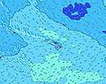 |  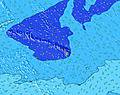 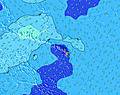 |  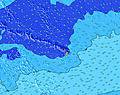 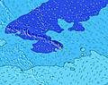 |  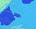 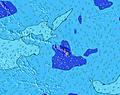 |  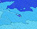 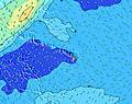 | 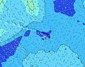 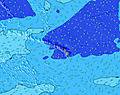  | |||||||||||||||||||||||||||||||||||||||||||||||||||
| Wave Height (m) & direction (?) | ||||||||||||||||||||||||||||||||||||||||||||||||||||||||||||
| Period(s) (?) | 11 | 11 | 11 | 11 | 11 | 11 | 11 | 12 | 12 | 12 | 12 | 12 | 12 | 11 | 11 | 8 | 8 | 8 | 8 | 8 | 8 | 8 | 8 | 8 | 13 | 13 | 13 | 12 | 12 | 12 | 12 | 12 | 12 | 11 | 11 | 11 | 11 | 11 | 11 | 11 | 10 | 8 | 8 | 8 | 8 | 8 | 8 | 7 | 7 | 7 | 7 | 7 | 8 | 8 | 7 | 7 | 17 | 16 | 16 | 16 |
Wave (?)Graph | ||||||||||||||||||||||||||||||||||||||||||||||||||||||||||||
| Energy (?) | 430 | 403 | 338 | 332 | 269 | 269 | 279 | 344 | 344 | 280 | 280 | 276 | 216 | 160 | 157 | 160 | 235 | 261 | 254 | 242 | 318 | 336 | 244 | 186 | 170 | 170 | 167 | 157 | 149 | 187 | 147 | 144 | 140 | 130 | 126 | 123 | 121 | 121 | 94 | 76 | 71 | 64 | 61 | 69 | 69 | 69 | 57 | 64 | 68 | 55 | 57 | 55 | 55 | 54 | 54 | 70 | 145 | 177 | 264 | 358 |
Wind (km/h) | ||||||||||||||||||||||||||||||||||||||||||||||||||||||||||||
| Wind State (?) onshore cross-onshore cross-shore cross-offshore offshore glassy | cross- off | cross- off | cross- off | cross- off | cross- off | cross- off | cross- off | cross- off | cross- off | cross- off | cross- off | cross- off | cross | cross- off | cross- off | cross- off | cross- off | cross- off | cross- off | cross- off | cross- off | cross- off | cross- off | cross- off | cross- off | cross- off | off | glass | glass | cross- on | cross | cross- off | off | off | cross- off | off | off | glass | glass | glass | off | off | off | off | off | cross | glass | off | cross- off | off | cross- off | cross- off | glass | on | glass | glass | glass | glass | glass | glass |
High Tide / height (m) | 8:28PM 0.50 | 8:12AM 0.08 | 9:36PM 0.51 | 10:26AM 0.13 | 10:31PM 0.52 | 11:26AM 0.22 | 11:16PM 0.51 | 12:13PM 0.33 | 11:56PM 0.48 | 12:55PM 0.44 | 12:34AM 0.44 | 1:38PM 0.55 | 1:09AM 0.38 | |||||||||||||||||||||||||||||||||||||||||||||||
Low Tide / height (m) | 10:45AM 0.00 | 5:46AM 0.06 | 12:16PM 0.04 | 5:24AM 0.05 | 2:25PM 0.06 | 5:31AM 0.03 | 3:59PM 0.06 | 5:45AM 0.00 | 5:12PM 0.06 | 6:05AM -0.03 | 6:16PM 0.06 | 6:28AM -0.07 | 7:17PM 0.06 | 6:54AM -0.10 | ||||||||||||||||||||||||||||||||||||||||||||||
Saturday 19 | Sunday 20 | Monday 21 | Tuesday 22 | Wednesday 23 | Thursday 24 | Friday 25 | Saturday 26 | |||||||||||||||||||||||||||||||||||||||||||||||||||||
| Sunrise | - | - | - | 6:15 | - | - | - | - | - | - | - | 6:13 | - | - | - | - | - | - | - | 6:13 | - | - | - | - | - | - | - | 6:11 | - | - | - | - | - | - | - | 6:11 | - | - | - | - | - | - | - | 6:11 | - | - | - | - | - | - | - | 6:09 | - | - | - | - | - | - | - | 6:09 |
| Sunset | - | - | - | - | - | - | 6:59 | - | - | - | - | - | - | - | 7:00 | - | - | - | - | - | - | - | 7:00 | - | - | - | - | - | - | - | 7:00 | - | - | - | - | - | - | - | 7:00 | - | - | - | - | - | - | - | 7:00 | - | - | - | - | - | - | - | 7:01 | - | - | - | - | - |
Rain (mm) | 1 | - | - | - | - | 1 | - | - | 1 | - | - | - | - | 1 | 1 | - | - | - | - | - | - | 1 | 2 | 1 | - | - | - | - | - | 1 | 1 | 1 | 1 | - | - | - | - | - | - | 1 | 1 | - | - | - | - | 1 | - | - | - | - | - | - | - | - | 1 | 1 | 1 | - | - | - |
| Temp. °C | 23 | 23 | 23 | 23 | 25 | 25 | 24 | 23 | 23 | 23 | 22 | 23 | 24 | 24 | 24 | 23 | 23 | 22 | 22 | 23 | 25 | 25 | 24 | 23 | 23 | 22 | 22 | 23 | 25 | 25 | 24 | 24 | 24 | 23 | 23 | 24 | 26 | 27 | 26 | 24 | 24 | 23 | 23 | 24 | 26 | 26 | 26 | 25 | 24 | 23 | 23 | 24 | 26 | 25 | 25 | 24 | 24 | 23 | 23 | 24 |
| Feels °C (?) | 24 | 23 | 23 | 23 | 25 | 24 | 23 | 23 | 23 | 23 | 22 | 23 | 24 | 23 | 24 | 23 | 24 | 22 | 23 | 24 | 25 | 25 | 24 | 23 | 24 | 23 | 24 | 25 | 27 | 27 | 25 | 26 | 26 | 25 | 25 | 25 | 27 | 29 | 28 | 27 | 26 | 24 | 25 | 25 | 27 | 28 | 29 | 27 | 26 | 25 | 25 | 26 | 29 | 27 | 28 | 27 | 27 | 26 | 26 | 27 |
- Map Icons:
 Break
Break Live Wave Height (m)
 Live Wind Speed (km/h)
 Surf Rating (10 Max)
 Ocean Swells (m)
- Wind Speed (km/h)
FREE! Surf-Forecast.com widget for your website
The surf report / weather widget below is available to embed on third party websites free of charge and provides a summary of our Tunnels surf forecast. Simply grab the html code snippet that we provide and paste it into your own site. You can choose your preferred language and metric/imperial units for the surf forecast feed to suit users of your site. Click here to get the code.


 Nearest