

- Forecast
- Maps
- Live
- Weather State
- Spot Information
Woolacombe Surf Forecast
/ Devon (North) (15 surf breaks) /

Woolacombe surfForecast / Devon (North) / UK
How big are the waves at Woolacombe today?
The current surf forecast for Woolacombe at 10AM is: 0.6m 13s primary swell from a West direction and 0.6m 8s secondary swell from a West-southwest direction (forecast issued at 06:00am April 19). An open ocean swell of 0.7m 4s is not directed at the surf break. The wind direction is predicted to be offshore.
| Time (BST) & Date | Wave Height | Wave Period |
|---|---|---|
| Morning (19 Apr) | 1.5ft (0.5m) | 14s |
| Afternoon (19 Apr) | 2ft (0.6m) | 13s |
| Evening (19 Apr) | 2ft (0.6m) | 12s |
Table - waves today at Woolacombe. (Swell directed towards the surf break)
Saturday 19 | Sunday 20 | Monday 21 | Tuesday 22 | Wednesday 23 | Thursday 24 | Friday 25 | Saturday 26 | |||||||||||||||||||||||||||||||||||||||||||||||||||||
| 4 AM | 7 AM | 10 AM | 1 PM | 4 PM | 7 PM | 10 PM | 1 AM | 4 AM | 7 AM | 10 AM | 1 PM | 4 PM | 7 PM | 10 PM | 1 AM | 4 AM | 7 AM | 10 AM | 1 PM | 4 PM | 7 PM | 10 PM | 1 AM | 4 AM | 7 AM | 10 AM | 1 PM | 4 PM | 7 PM | 10 PM | 1 AM | 4 AM | 7 AM | 10 AM | 1 PM | 4 PM | 7 PM | 10 PM | 1 AM | 4 AM | 7 AM | 10 AM | 1 PM | 4 PM | 7 PM | 10 PM | 1 AM | 4 AM | 7 AM | 10 AM | 1 PM | 4 PM | 7 PM | 10 PM | 1 AM | 4 AM | 7 AM | 10 AM | 1 PM | |
Rating (10 max) | ||||||||||||||||||||||||||||||||||||||||||||||||||||||||||||
Swell Height Map |    |    |    |  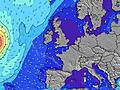 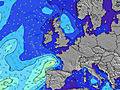 |  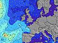 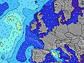 |  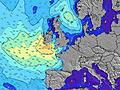 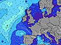 |  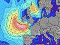 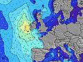 | 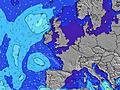 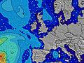 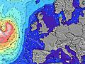 | ||||||||||||||||||||||||||||||||||||||||||||||||||||
| Wave Height (m) & direction (?) | ||||||||||||||||||||||||||||||||||||||||||||||||||||||||||||
| Period(s) (?) | 8 | 14 | 13 | 13 | 12 | 12 | 12 | 12 | 12 | 12 | 12 | 12 | 11 | 11 | 11 | 11 | 11 | 11 | 10 | 10 | 10 | 6 | 10 | 10 | 10 | 10 | 10 | 10 | 10 | 6 | 7 | 8 | 8 | 9 | 9 | 9 | 9 | 9 | 9 | 9 | 10 | 10 | 10 | 10 | 12 | 12 | 12 | 14 | 14 | 14 | 13 | 13 | 13 | 13 | 13 | 13 | 13 | 13 | 12 | 12 |
Wave (?)Graph | ||||||||||||||||||||||||||||||||||||||||||||||||||||||||||||
| Energy (?) | 39 | 69 | 126 | 123 | 113 | 108 | 108 | 108 | 108 | 106 | 103 | 99 | 94 | 89 | 86 | 85 | 83 | 57 | 53 | 31 | 31 | 89 | 377 | 495 | 432 | 353 | 290 | 250 | 250 | 110 | 176 | 593 | 445 | 413 | 463 | 200 | 498 | 450 | 399 | 311 | 326 | 296 | 255 | 208 | 266 | 280 | 280 | 713 | 684 | 725 | 683 | 700 | 700 | 704 | 600 | 582 | 573 | 556 | 530 | 425 |
Wind (km/h) | ||||||||||||||||||||||||||||||||||||||||||||||||||||||||||||
| Wind State (?) onshore cross-onshore cross-shore cross-offshore offshore glassy | off | off | off | off | off | off | off | off | off | off | off | off | off | off | cross | cross | on | on | cross- on | on | on | on | on | on | cross- on | cross- on | cross- on | cross- on | cross- on | cross | cross | cross | cross- on | on | on | on | on | on | cross- on | cross- off | off | off | off | off | cross | cross- off | cross- off | cross- off | cross- off | cross- off | cross- off | cross- off | cross- off | cross- off | cross- off | cross- off | cross- off | cross- off | cross- off | off |
High Tide / height (m) | 10:09AM 7.45 | 10:30PM 7.33 | 10:55AM 6.98 | 11:27PM 6.90 | 12:04PM 6.58 | 12:54AM 6.70 | 1:41PM 6.56 | 2:30AM 7.01 | 3:09PM 7.05 | 3:42AM 7.68 | 4:13PM 7.78 | 4:39AM 8.41 | 5:06PM 8.48 | 5:30AM 9.02 | ||||||||||||||||||||||||||||||||||||||||||||||
Low Tide / height (m) | 3:46AM 2.27 | 3:58PM 2.53 | 4:30AM 2.73 | 4:47PM 3.01 | 5:38AM 3.12 | 6:09PM 3.37 | 7:20AM 3.16 | 8:02PM 3.23 | 8:48AM 2.70 | 9:22PM 2.61 | 9:54AM 2.02 | 10:21PM 1.88 | 10:48AM 1.34 | 11:12PM 1.22 | 11:37AM 0.80 | |||||||||||||||||||||||||||||||||||||||||||||
Saturday 19 | Sunday 20 | Monday 21 | Tuesday 22 | Wednesday 23 | Thursday 24 | Friday 25 | Saturday 26 | |||||||||||||||||||||||||||||||||||||||||||||||||||||
| Sunrise | - | 6:13 | - | - | - | - | - | - | - | 6:11 | - | - | - | - | - | - | - | 6:09 | - | - | - | - | - | - | - | 6:07 | - | - | - | - | - | - | - | 6:05 | - | - | - | - | - | - | - | 6:03 | - | - | - | - | - | - | - | 6:01 | - | - | - | - | - | - | - | 6:00 | - | - |
| Sunset | - | - | - | - | - | 8:17 | - | - | - | - | - | - | - | 8:20 | - | - | - | - | - | - | - | 8:21 | - | - | - | - | - | - | - | 8:22 | - | - | - | - | - | - | - | 8:24 | - | - | - | - | - | - | - | 8:25 | - | - | - | - | - | - | - | 8:28 | - | - | - | - | - | - |
Rain (mm) | 2 | 2 | - | - | - | - | - | - | - | - | - | - | - | - | 1 | - | 2 | 1 | - | - | - | - | - | - | - | - | - | - | - | - | 1 | 4 | 4 | 2 | - | 1 | - | - | - | - | - | - | - | - | - | - | - | 1 | 3 | 1 | - | - | - | - | - | - | - | - | - | 1 |
| Temp. °C | 11 | 11 | 10 | 11 | 11 | 11 | 10 | 10 | 9 | 8 | 8 | 10 | 12 | 11 | 10 | 10 | 9 | 9 | 10 | 11 | 10 | 10 | 10 | 10 | 10 | 9 | 10 | 12 | 12 | 12 | 10 | 10 | 11 | 10 | 10 | 10 | 10 | 10 | 10 | 9 | 8 | 8 | 10 | 12 | 11 | 11 | 10 | 9 | 9 | 10 | 10 | 11 | 12 | 11 | 11 | 11 | 11 | 10 | 11 | 11 |
| Feels °C (?) | 4 | 5 | 5 | 5 | 6 | 6 | 5 | 4 | 2 | 1 | 1 | 3 | 7 | 8 | 7 | 8 | 7 | 6 | 8 | 6 | 5 | 5 | 6 | 6 | 7 | 5 | 6 | 8 | 8 | 7 | 4 | 1 | 5 | 5 | 4 | 4 | 5 | 5 | 6 | 6 | 5 | 5 | 6 | 8 | 9 | 9 | 6 | 6 | 6 | 7 | 7 | 7 | 9 | 9 | 9 | 9 | 9 | 8 | 8 | 9 |
- Map Icons:
 Break
Break Live Wave Height (m)
 Live Wind Speed (km/h)
 Surf Rating (10 Max)
 Ocean Swells (m)
- Wind Speed (km/h)
FREE! Surf-Forecast.com widget for your website
The surf report / weather widget below is available to embed on third party websites free of charge and provides a summary of our Woolacombe surf forecast. Simply grab the html code snippet that we provide and paste it into your own site. You can choose your preferred language and metric/imperial units for the surf forecast feed to suit users of your site. Click here to get the code.


 Nearest